
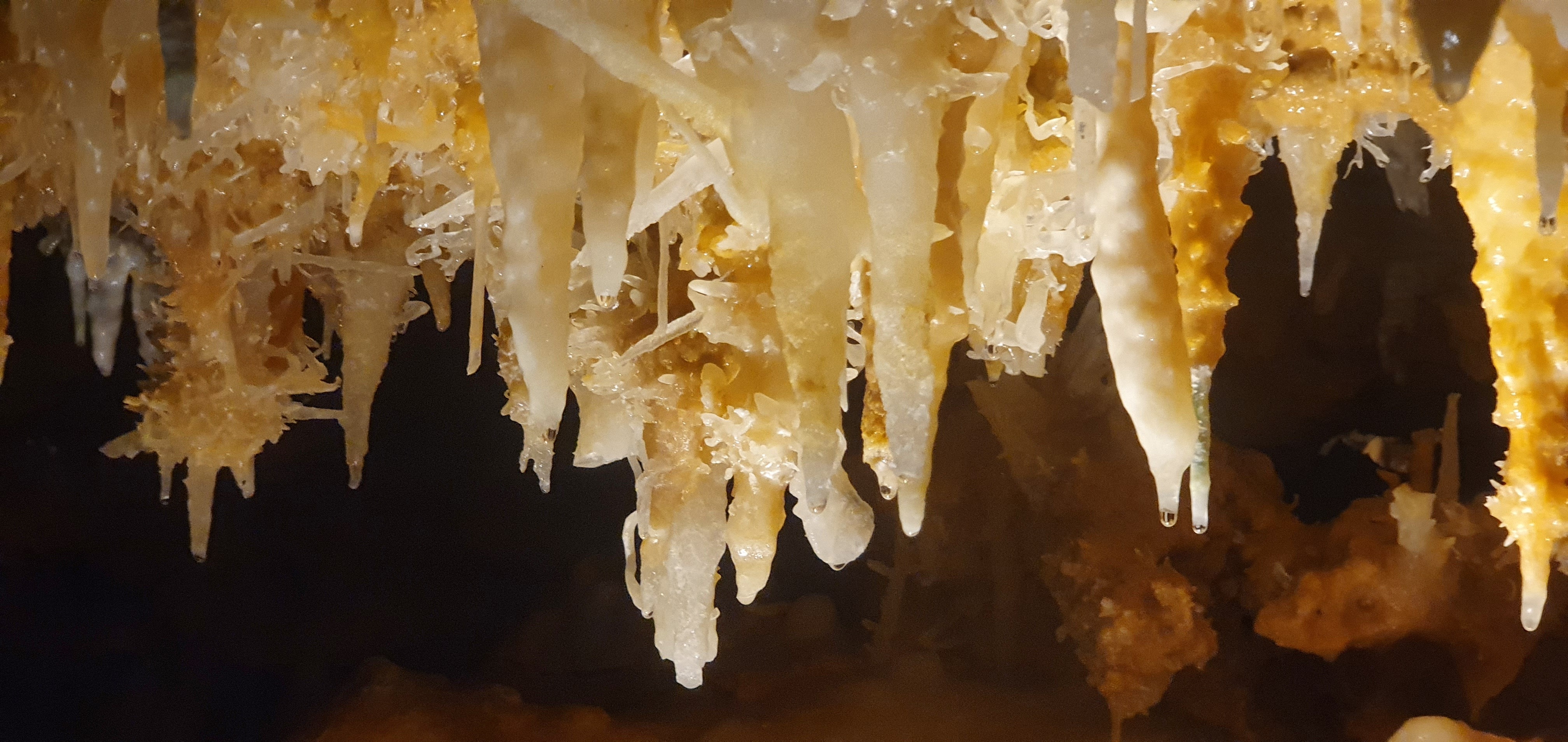
Helectites in Grotte de Grand Roc, Dordogne, France. Photo by Linda Wilson
|
|
There's
a distinctly French flavour to this issue, so break out some olives, a
baguette, cheese and any some other tasty morsels that take your fancy
and settle down for some armchair caving.
It's been a busy summer underground, with several members heading off to
the International caving Symposium in Haute Savoie, France, supported
by grants from the Tratman Fund and the Oliver Lloyd Memorial Fund and
by the time this newsletter hits members' screens, a group will be in Co
Clare continuing surveying work in Coolagh River Cave, with support
from both Funds. There have been other trips to France and some closer
to home as well. We'll spread this material over several issues so that
you at least have a fighting chance of reaching The End.
One thing that is clear from this issue and other recent ones, is that
UBSS has close links with many other clubs, not just locally on Mendip
and South Wales, with UBSS members also members of clubs like the BEC,
The Wessex CC and SWCC, but we also have strong links with various clubs
north of Bristol, including the Hades CC (through David Hardwick), the
Grampian Spelaeological Group (including Paul Savage, Linda Wilson and
Graham Mullan, Tony Boycott, Julian and Carol Walford) and the
Gloucester Speleological Society (Mark Tringham). It would be great if
we could get some joint trips with other clubs both locally and further
afield and, as a recent article by Mark Tringham showed, there's some
excellent caving north of the border in Scotland. And through the Hades
and the GSS, there's plenty to explore in the Forest of Dean as well.
For everyone who's done some caving recently, please tell us where you've been using Zac's short trip report form. Come on, who's been caving?
If you have recently graduated, it's likely that your university email
address will switch off soon, so please remember to let us have another
email address for you so we don't lose contact, and if you're still a
student, please remember to sign up again asap. The union site is now
available for sign ups. Student membership is only £10. You can sign up on the Students' Union site.
You can find all the back issues of the monthly newsletter online.
Zac and Linda
|
|
A WORD FROM THE CHIEF WORM
Hi everyone,
Hope you're all looking forward to getting back together for the new
academic year! Details for everything UBSS in the next term will be
circulated early September. I can't wait to see you all!
With worm wishes,
Mia
(Chief Worm and Student Prezz)
|
|
WARNING!
Rockfall in Eastwater Cavern. Care
needed. The following information has been received from Wayne
Starsmore, Conservation Officer for the Council of Southern Caving
Clubs.
There has been a rockfall in the rift connection between the bottom of
Dolphin Pot and the chamber before Dolphin Pitch. A section of the roof
and some of the left-hand wall (looking down the rift) had become
detached. CSCC C&A Officer, Wayne Starsmore spent time bringing down
the remaining loose rock and stacking it neatly. The area may still
have some unstable sections and should be treated with caution.
|
|
CAVES OF SOUTHERN IRELAND
And now for the intellectual bit! It's publication time ....
The long-awaited (by Graham, anyway, as he's the editor!) Caves of
southern Ireland has now been delivered! This is a companion
volume to our award-winning Caves of Mid-West Ireland but
covering, as the title suggests, the southern part of Ireland, counties
Kerry, Cork, Limerick, Tipperary, Waterford, Kilkenny, Laois and Offaly
(there are no known caves in Wexford or Carlow - a challenge!!).
The book is in the same format as the previous one but is softbound
rather than hardbound. As with that tome it has been produced in
association with the Speleological Union of Ireland (SUI).
The new book will be formally launched in Ireland at the SUI annual
conference at the end of October, but copies are available in Bristol
immediately, and we can have a mini-launch in the pub, if anyone is
interested. Details to follow.
The retail price will be £15 but with a reduced price to members of £10.
P&P will be £5, similar to Caves of Mid-West Ireland. There will be a sales link on the website, but members wishing to obtain a copy should contact Graham direct for their discount.
PROCEEDINGS
The obligatory photo of Adelle Bricking's
bum, digging in Fishmonger's. Nope, she's not had an unfortunate
accident. The place is just bloody muddy! Photo by Linda Wilson.
And wearing the other half of Graham's editor’s hat, the latest volume of Proceedings has now gone to print (at last!!!) and should be distributed to members in the near future.
The papers in this issue all concern the cave site of Fishmonger’s
Swallet in South Gloucestershire. They give the background to the cave
and its excavation and set out some of the extremely interesting results
coming from analysis of the finds, especially concerning the human
remains and those of numerous dogs.
These have been dated to the late pre–Roman Iron Age and break new
ground in our understanding of this period. For those who prefer lighter
bedtime reading, Linda has offered to produce 100-word drabble
summaries of each paper on request. The Reduced Shakespeare Company has got nothing on her!
Members receive a copy of this free but for anyone else wanting a copy
(we're sure all authors will want copies for their proud parents,
friends, family, the landlord of their local pub etc), a sales link will appear on our website as soon as we have it.
Graham Mullan
|
|
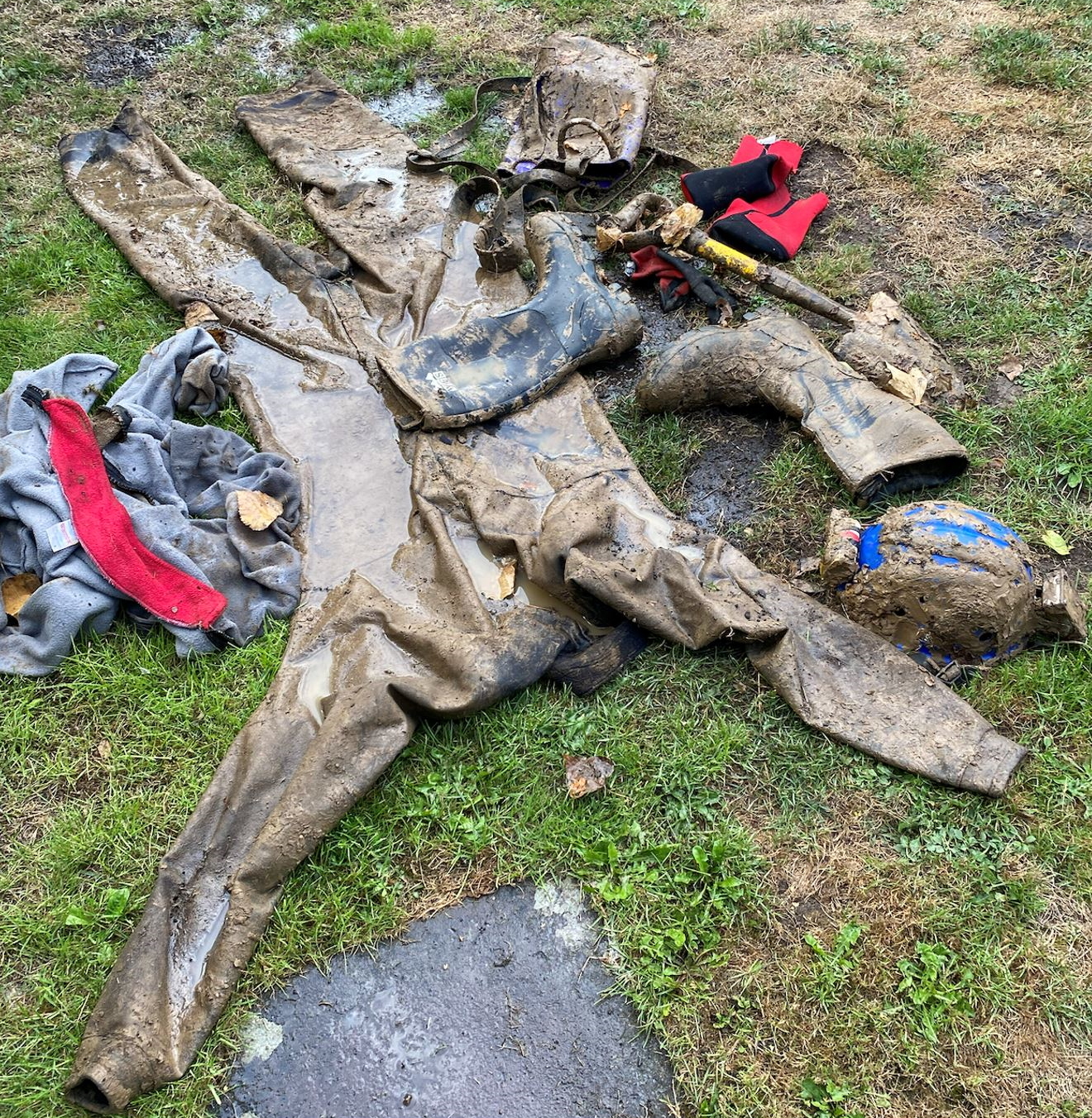
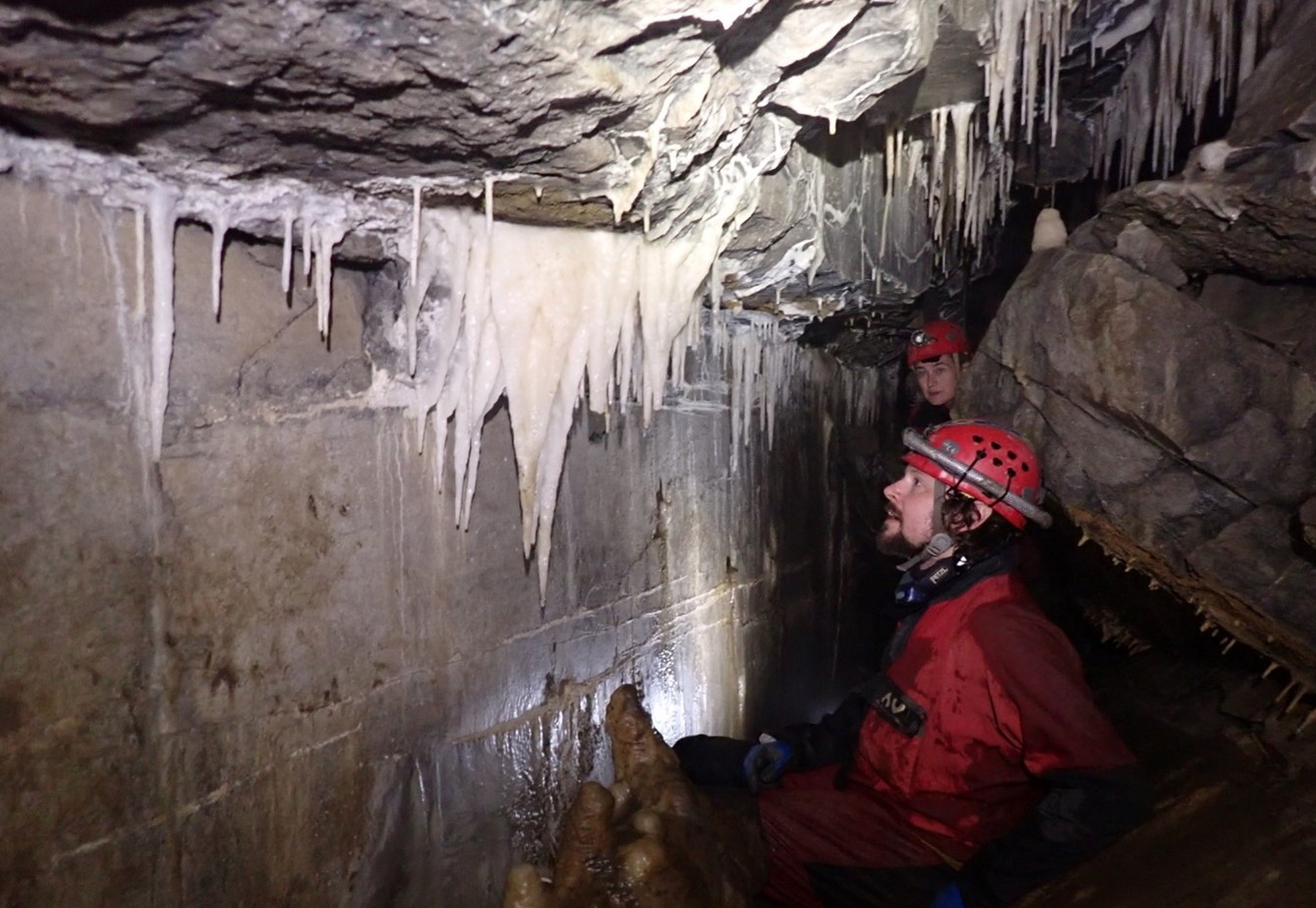
WATERGATE? MORE LIKE MUDGATE!
There are always some trips that
the memory does us the courtesy of blurring. It seems Watergate in
Swildon's comes into that category, although Sioned does seem to have
enjoyed her return match with the cave on this occasion.
21/08/22. Sioned Haughton, Ash Gregg and Si Hadfield. Report by Sioned Haughton.
The three of us did this trip three or four years ago so we thought we’d
revisit it. Last time with route-finding issues and bailing it took us
two attempts to complete and I recalled very little from either of those
trips apart from that they were fun. Having now repeated it, I can
report that Watergate is the sort of trip that could very easily not be
fun, and I feel fortunate to have actually enjoyed it again!
The walk over the fields was very sweaty and water levels were almost non-existent in the entrance chamber.
As I said, I had forgotten some important details (like the 14m ladder
pitch in Lower Fault Chamber) but fortunately Ash reminded us. At the
bottom of this we checked Link Pool - it was open so no need for bailing
there. Next time I think we could get away with just an 8m ladder since
the bottom of the pitch, even though it bells out, is a pretty
straightforward free climb. The top section is probably also
free-climbable but it would be a solid thrutch up a straight sided
chimney clarted in mud. As Si pointed out, it is exactly the sort of
thing you don’t want to do in a wetsuit.
We headed on through Blue Pencil, enjoyable as always, then quickly
located the climb that had taken us so long to find the previous time.
Probably because it looks so unlikely. This basically sets the tone for
the rest of the trip, except you don’t have any other options! After
much physical deliberation I accepted that I required a human foothold
for one of the climbs, which Si thankfully back tracked along a
particularly ‘entertaining’ section of passage to provide. (Top tip - don’t go last or, if you’re Si, don’t go in front of Sioned)
After this we encountered the ducks - double duck was a bit diesel-y,
definitely not a place to linger - and the consensus was that the
proportion of mud to water was much greater than on our last visit. (Top tip - take a hood.)
Watergate 1 was full, as expected, but with no bucket there. I have the
(mis)fortune of having a helmet with no holes and this was the bailing
implement of choice until Ash gave up and went back to get a bucket.
Probably 20 minutes of vigorous bailing after that. Once through, Ash
was about to start bailing Watergate 2 but was saved by Si who had found
another very unlikely looking bit of passage. Cue another ridiculously
slippery climb and more hysterical flailing around (Ash providing the
footholds this time) before we arrived back at Link Pool.
On the way out, we spent a good ten minutes wallowing in the streamway to try to remove the worst of the mud.
We went for dinner at the Castle of Comfort as the Hunter’s was closed
and the Vic had stopped doing food. We were ridiculously grateful that
they were still serving, and we probably would have eaten anything by
that point but it was actually a decent alternative.
Sioned Haughton
|
|
HAPPY 25th ANNIVERSARY!
Hardwick Hall, Fishmonger's Swallet. Photo by David Hardwick.
3/8.22, David Hardwick, Andy Brander. Report by David Hardwick. Time: 4 hrs (3hrs digging). Tackle: Crowbar and Short handled spade
On the 30th of August 1997, the breakthrough was made into the first of
the chambers of Fishmonger’s Swallet, Alveston, South Gloucestershire.
This date is easy to remember because it was in the early hours of the
following morning that Princess Diana died. I was due to lead an Otter
Hole trip that day so wouldn’t be able to visit the new chamber until
later in the week. I ended up spending an extended time under Chepstow
racecourse due to the impossibility of getting a reliable weather
forecast with all channels covering the overnight events in Paris. (NB,
this was before internet and mobile phones with weather apps).
30th August 2022 was exactly 25 years after the major breakthrough, so
an anniversary trip to dig at the end and to go for a pint afterwards to
celebrate seemed to be in order. Andy Brander and I therefore met at 6
o’clock and headed off to the dig at the far end of the Mudlands.
If the cave was going to be nice, we would find passages “measureless to
man” and we would name the streamway we found “Anniversary Passage” or
enter into “Silver Jubilee Chamber” laughing that the new survey, soon
to be published in UBSS Proceedings, was already out of date. Suffice it
to say that any resurveying and use of suitable anniversary themed
names will have to wait. We did however enlarge the end of the dig and
have reached the actual point that the current survey extends to (i.e.
the last measurement was taken looking into the “too tight” part of the
dig) and there is now a further way on for at least another 3m that will
need more digging.
Tringham’s Buttocks. An unusual geological
feature (shape highlighted in yellow) to find in a cave as it is
typically found in sandstone. Image by David Hardwick.
Whilst on the subject of diggers over
naming far too many features in caves (as appears to be a theme in
recent UBSS newsletters) I spent most of the evening digging in a pile
of brown sticky material directly beneath Tringham’s Buttocks (see
above). That sounds worse than it actually is but only marginally so!!
For those wanting to know more about this cave the next the UBSS
Proceedings (currently at the printers) is almost entirely focused on
Fishmonger’s Swallet and its archaeology but also includes a section on
the development of the cave by Mark Tringham and one on the history of
exploration (written by me).
Typical Kit condition after digging trip in Fishmongers – Thankfully we don’t live in an area with a hosepipe ban!!! Photo
by David Hardwick. Don’t Tell Jack but that’s his helmet & light
under there somewhere !!!! Always a good cave to wear borrowed kit in !
With regard to toasting the anniversary
after our trip … once again we managed to miss last orders, partly due
to my watch being slow but also from me forgetting how long it takes to
de-kit when caked in the famous Fishmonger’s Swallet mud. It does, of
course, mean that to celebrate the 25th anniversary we ought to have a
“proper do” with a meal and drinks and without having to actually get
filthy dirty beforehand - which appears to be a far better suggestion.
David Hardwick
|
|
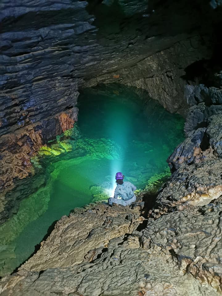
WHO SAYS SIZE DOESN'T MATTER?
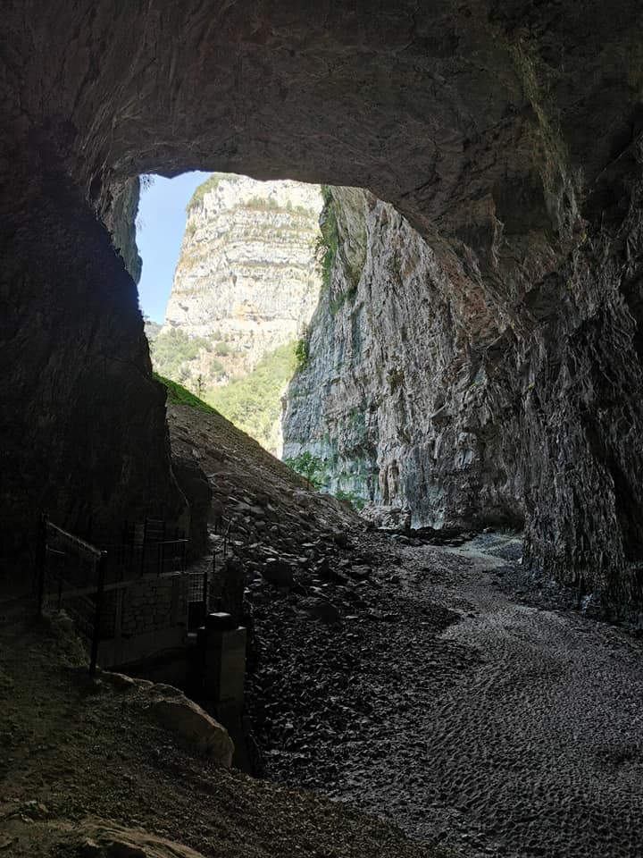
Entrance of the Grotte de Bournillon. Photo by Paul Mackrill.
French fun didn't end with the conference. So over to Merryn for a trip to the cave with the largest entrance in the country.
After the UIS I stayed out for another week of caving and canyoning with
SUSS (Sheffield university speleological society). One of these trips
was the Grotte de Bournillon, in the Isère Department
of France, in the Vercors Massif. As the largest cave entrance in
Europe - 105m high and 60m wide - it's impressive just to gape at from
the outside.
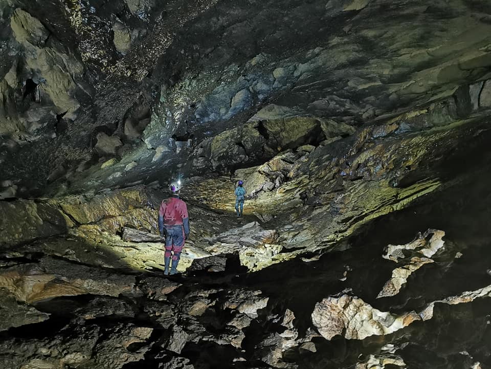
Champs-Élyséen, Bournillon, Photo by Paul Mackrill.
I went with Glen Sankey and Paul Mackrill, who took some amazing photos
of the cave passage despite its light-swallowing black mud deposit on
the walls. Paul was also a fountain of knowledge on the hydrology of the
cave. He had last been in 30 years ago, when the water levels were much
higher, and was excited that due to the present drought, a way through
the Labyrinth (reflector and tape marked) allowed access to further huge
passages and the two sumps, Alpha and Beta.
Sump Alpha, Bournillon. Photo by Pauk Mackrill.
The scale of the train tunnel sized
phreatic passages and scallops on the wall are testament to the volume
of water that can pour out of the cave when in flood, 50m^3/s, having a
very large drainage catchment.
Scallop Passage, Bournillon. Photo by Paul Mackrill.
There was something very eery about imaging
the space we were in recently underwater, evidence of this can be seen
in pictures showing an old dive line above our heads!
After having seen so many beautiful sumps, I was very tempted to go for a
swim, and had an icy refreshing dip in the entrance pool to prepare
myself for the 30C heat outside.
Come on in, the water's lovely! Entrance pool, Bournillon. Photo by Paul Mackrill.
This cave was definitely a sweaty alpine
temperature and could probably have been enjoyed better in a t-shirt,
not my thermals and onesie!
Merryn Matthews
|
|
RETURN TO THE GOURNIER
Entrance lake, Grotte de Gournier. Photo by Merryn Matthews.
There are some caves that need more
than just a floatation device to navigate, so if you haven't got a
handy boat, or an inflatable unicorn, despair not, Merryn assures us
that other forms of transport are available.
Some may remember a trip report of my last time in the Gournier, where
antics with an inflatable dingy made for an entertaining spectacle to
tourists visiting the entrance lake. This time I managed to be even more
of a spectacle, as the chosen SUSS lake crossing vessel was a paddling
pool with no paddles.
A perfectly reasonable mode of transport! Photo by Merryn Matthews.
I did not trust the ‘boat’ on the way
across, so swam, and spent the rest of the cave very cold, and in only a
wetsuit. But I assure you the ride was actually a surprisingly comfy
four-seater on the return journey.
Merryn Matthews
|
|
OH NO, NOT MORE PIGGIN' MEANDERS!
Merryn Matthews running through her pre-caving workout. Photo by Elaine Oliver.
Zac Woodford went to France hoping
for caverns measureless to worms, but instead found meanders, and yet
more meanders, and appears to have taken it personally.
Hopefully most, if not all, of our readers are aware that a small
contingent of UBSS members attended the UIS conference in Chambery in
July. I know that many of you are aware of this because we met you there
and to you I say hello again, I hope you had a safe Journey back. And
while we did spend much of our time at the conference (40 minutes just
for a call out at one point) we would’ve been remiss if we had not
capitalised on the opportunity to explore the regions spelaeological
delights.
One such expedition was Tanne Névé - Tanne aux Cochons. Situated on a
mountainside north of Chambery the entrance was a little way up a well
trafficked tourist path. I had the pleasure of being joined by Elaine
Oliver, Elliott McCall, Merryn Matthews, Gabriel Littler, and Rich Sore.
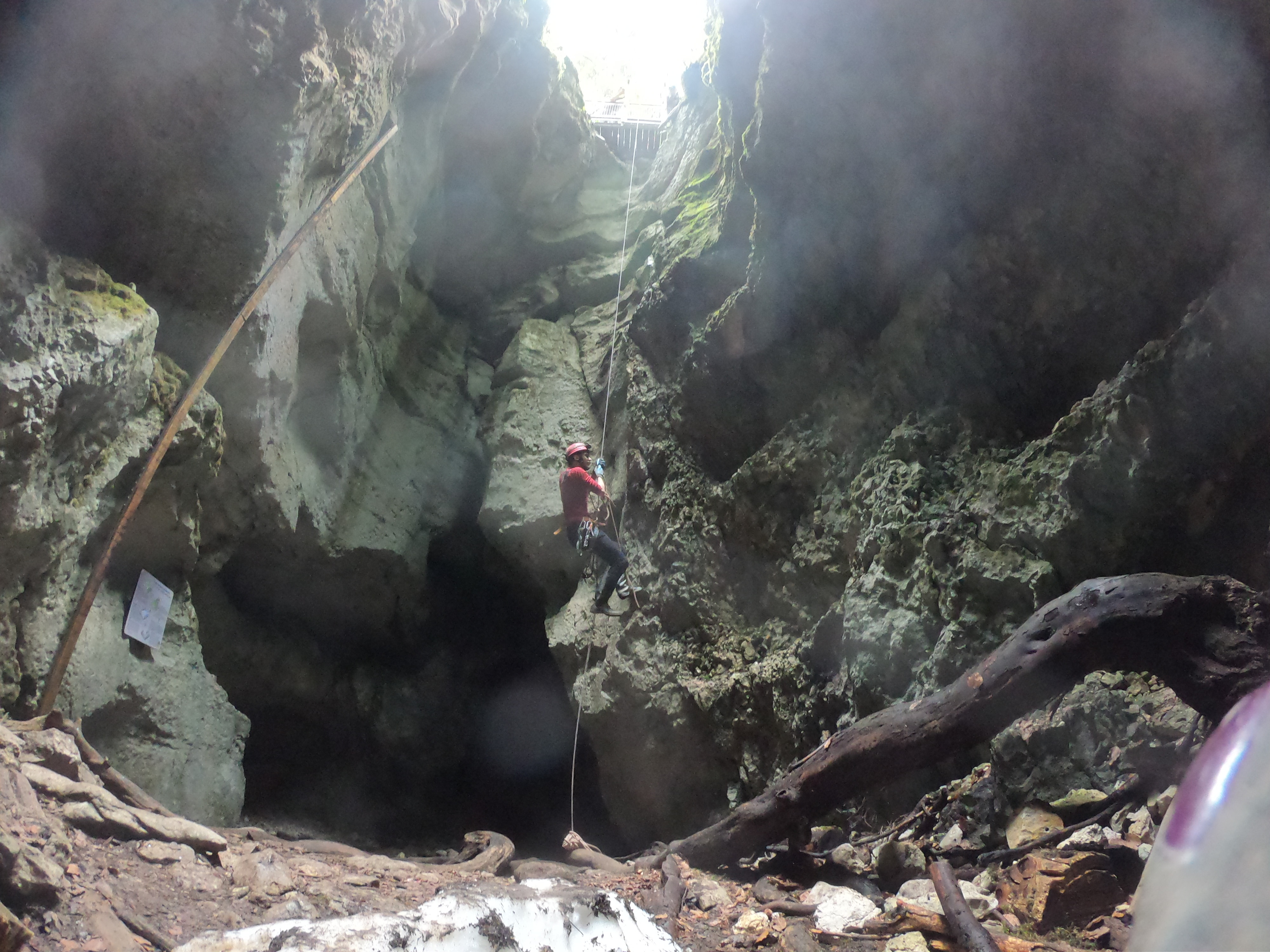
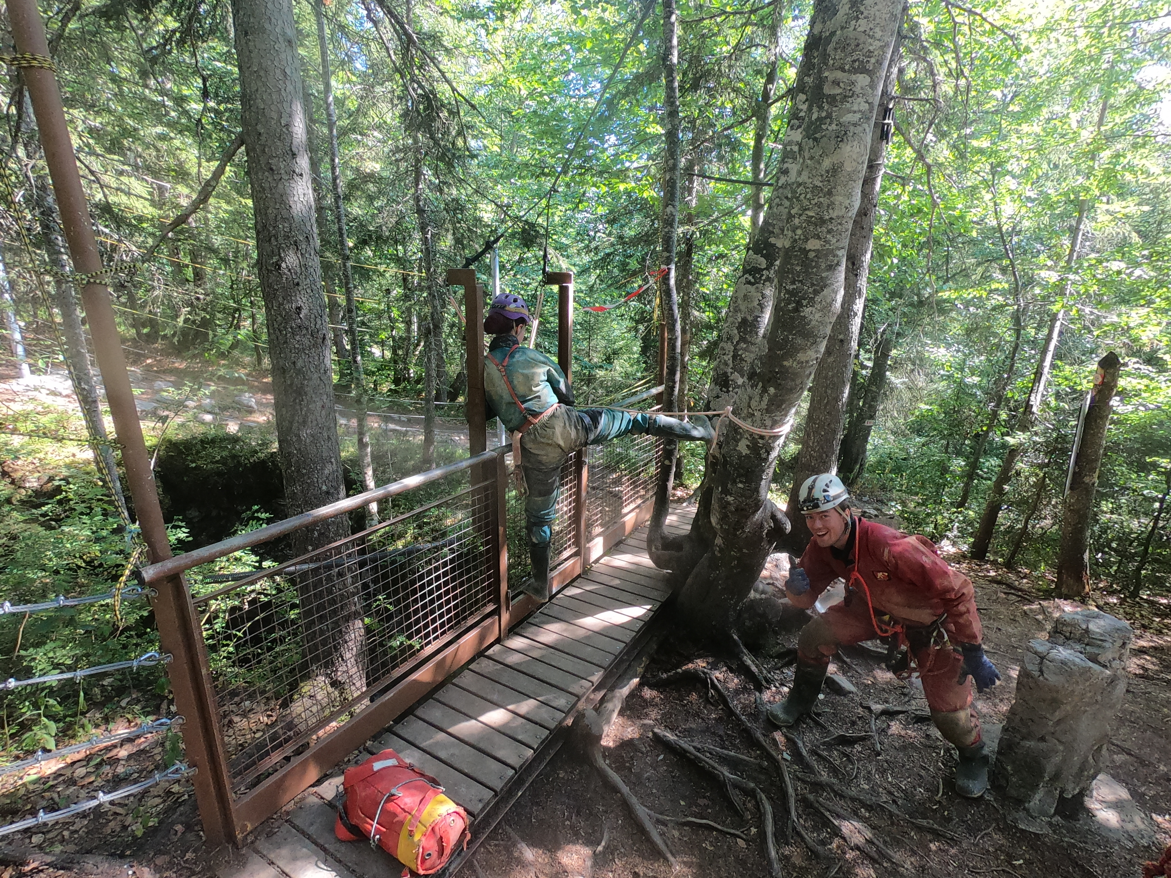
Elliott McCall on the rope in the entrance pitch. Photo by Elaine Oliver.
The entrance is a large pot with an
overhanging balcony that we abseiled off (the cave was pre-rigged as
part of the conference). At the bottom of the pit we re-grouped by a
small pile of snow, the remains of a glacier. This part of the cave, as
we found out from a info board on the surface, is accessible to tourists
via a less vertical entrance. From here we proceeded through to another
chamber, also tourist accessible, to reach the “professional” part.
It was here that we were overtaken by a group of French cavers. For the
first time, and having just done the next series of pitches another
group overtook us. The cave was then relatively horizontal until another
pitch dropped us down into the streamway where we continued upstream.
Where we dropped in, the streamway was quite wide but it soon narrowed
into a meander. Which went on and on and on.
Just before we stopped for lunch we bumped into a very lost looking
Frenchman who apparently had mislaid the other two members of his group
(this group being the second one to overtake us). It turns out they had
gone downstream, Merryn had tried to follow to correct them but had to
turn around after they went too far.
Eliott enjoying haute cuisine, dining out in France. Photo by Elaine Oliver.
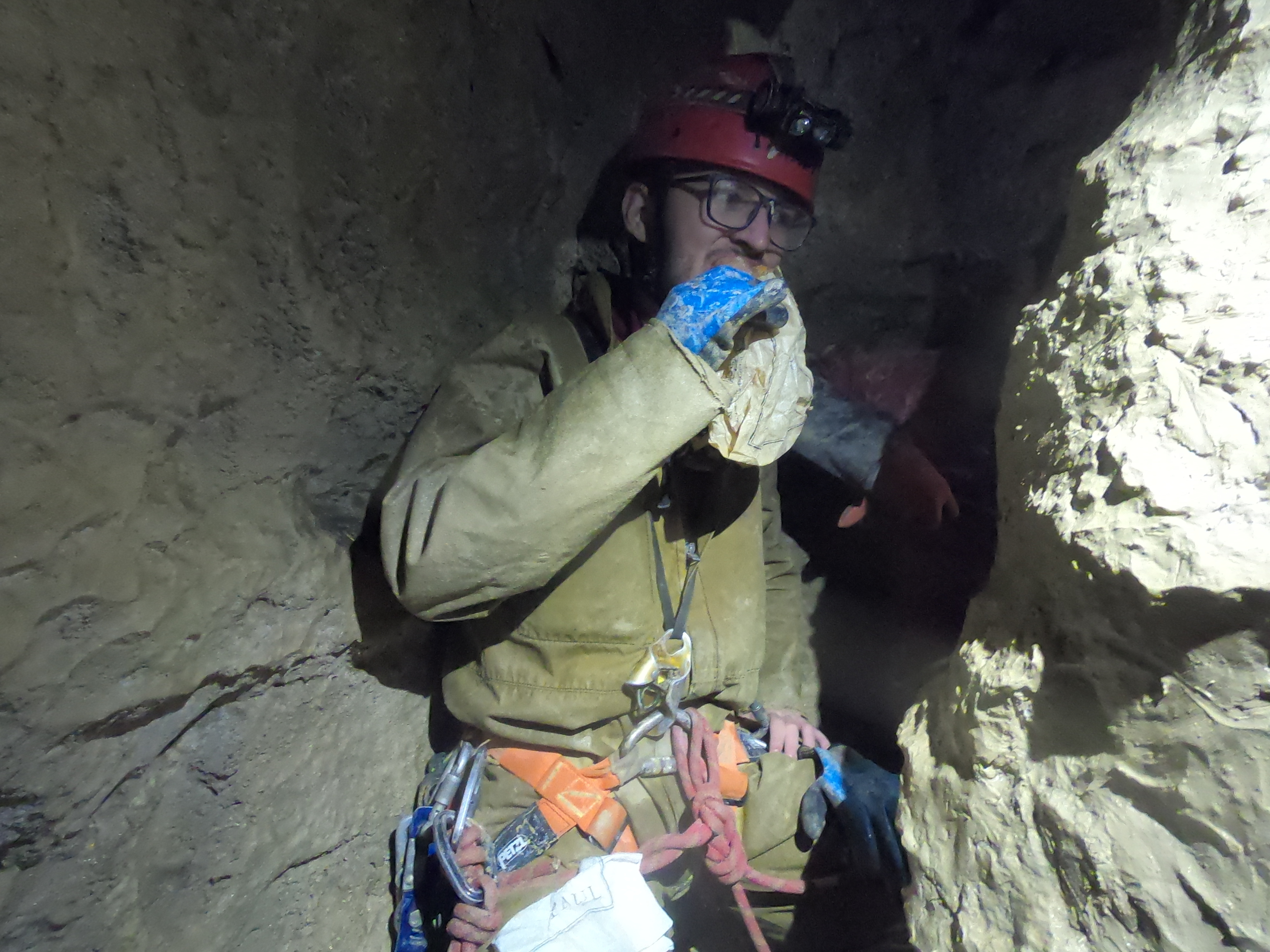
We stopped for lunch in a horribly tight
grotty oxbow lined with thick mud where our food had to be passed along
the line. We joked that we’d turn the next corner and find a wonderfully
huge chamber which would have been far better for lunching. Sod’s law,
this happened. The chamber had the next pitch in it, a small vertical
one which led into more meander.
This meander was followed by more meanders, then a little more
meandering before finally - some meanders! There were some short
vertical pitches in there as well... somewhere. Merryn, Gabriel and I
also took the opportunity to give Elliot a heart attack by waiting with
our lights off in an upper part of the streamway that cut through to a
lower part, shouting down at him as he passed.
Eventually we reached a large dam in the passage which signified the
start of the series of ascending pitches that would take us to the
surface. The first few were in the higher part of the streamway and led
to a short tunnel which came out at the bottom of a giant aven which
ascended all the way to the surface. The exit was actually higher than
the entrance giving us the opportunity to peer into the entrance again.
The others even went into another small nearby cave before entering
Tanne Névé via the tourist route and ascending up the balcony.
This was an enjoyable trip but several comments were made about the
meanders. I went to France because I was told the caves were nice and
big. That meander was not. Nevertheless I would still recommend
visiting.
Zac Woodford
|
|
LITTLE MAN, BIG DICK
The 'sorceror' of St Cirq. Reproduction in the museum. Photo by Linda Wilson.
A trip to a French showcave proves that homo sapiens sapiens have been carving cocks on rocks for a very long time!
To
get away from the scorching heat, Linda and I took a guided tour into
the Grotte du Sorcier, otherwise known as the Cave with the Little Man
with the Big Dick', a small show cave near Les Eyzies in the Dordogne,
where we saw some rather impressive carvings . A horse, the man himself
(aka the sorcerer. Right! Presumably calling him a sorceror sounds more
impressive than just calling him a man), bison, various animal heads,
etc.
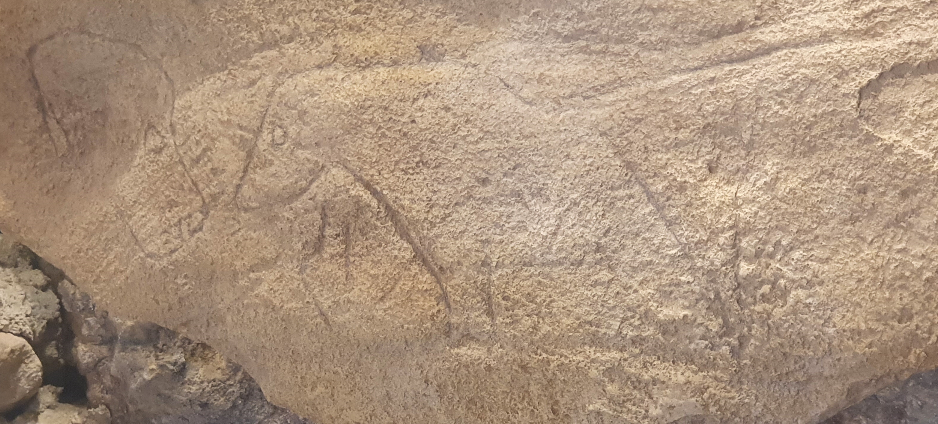
Possible human head (left), horse (right). Reproduction in the museum. Photo by Linda Wilson.
The engravings are believed to be from the
Magdelanian period (17.000 to 12,000 years ago). Anthropomorphic
(representing people) figures are rare in cave art and the museum
contains photos of all of these. most of which are in caves not open to
the public, so St Cirq is a good opportunity to see one in the flesh, so
to speak.
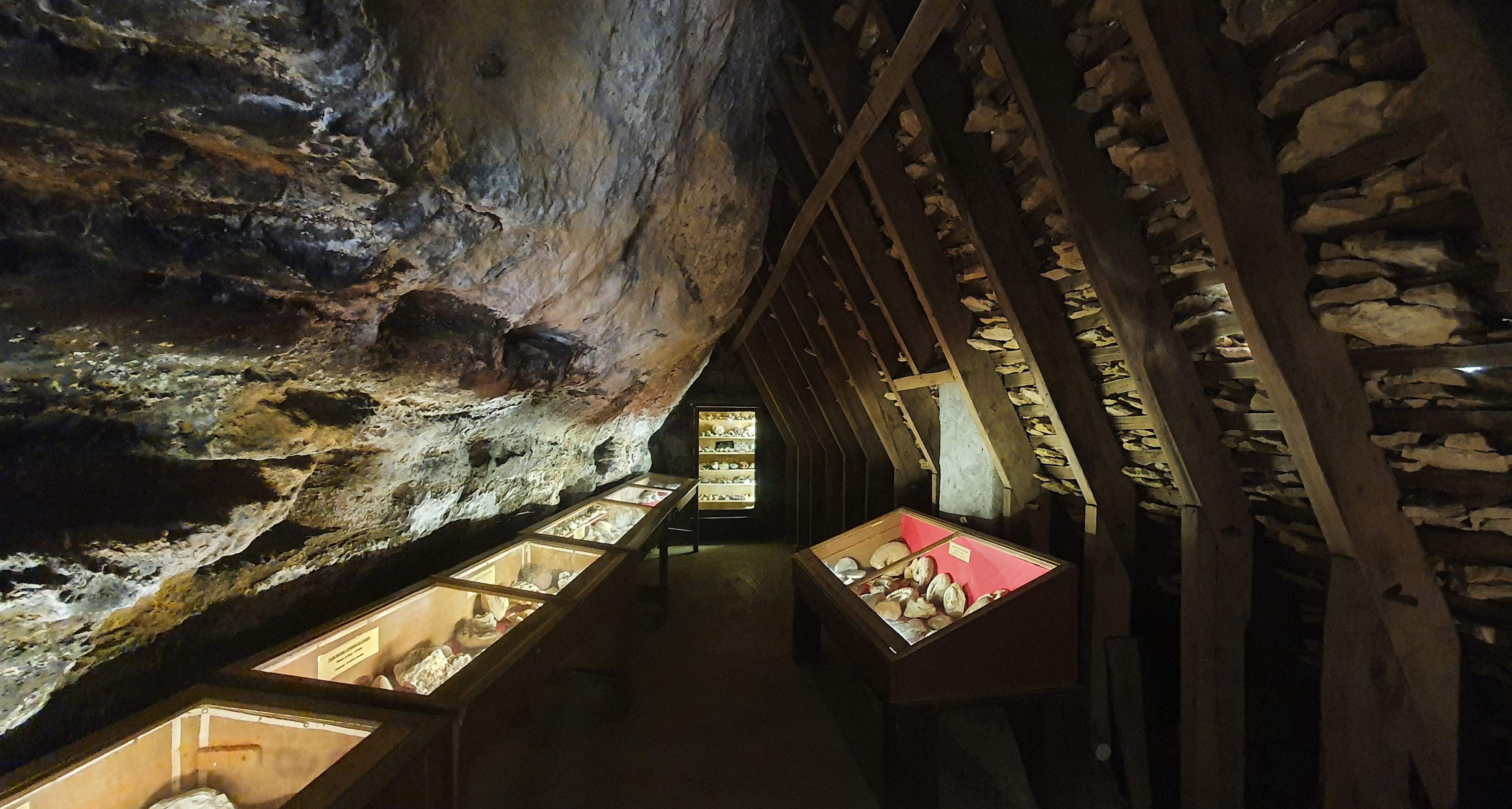
Museum. Natural rock wall on the left. Righthand side is the interior of the lauze roof.
There's also a small museum on the site,
from which it's possible to see one of the incredibly impressive stone
'lauze' roofs from the inside. This is a traditional style of roofing in the area, using 'flagstones'. These are incredibly heavy and require strong trusses to hold the weight!
After the tour through the little show cave (yay for the little man with
the big dick!), we were released to go on our own into the small side
rock shelters. After a few fairly high steps in the stone, we turned
left at the fork for the larger cavern. Yeah, they've added metal
railings on both sides of the steep rock ascent around the edge of the
rock - the steps are uneven and pretty worn. It would have been
'interesting' doing it in sandals without the railings ...
Health and Safety is more of an aspiration
than a reality in some French tourist sites. Jan Walker returning to
ground level. Photo by Linda Wilson.
We arrived at the first level of the rock
shelter and looked around. There's an interesting view from that level,
but then Linda discovered that the ladder up to the top level still
existed, and there was no sign that said Interdit, so, of course, we
went up the steep wooden ladder, and used the ropes to help us up the
last very steep stone step and up an awkward acsent. There was an even
better view! Tidy little cave. :). Then back down the same stone steps
and wooden ladder, and down a narrow passage farther into the rock,
which ended after about ten metres at a rather ochrey looking squeeze,
so, not having worn caving kit, we turned back and went down the steep
rock steps and up the less steep stairway to the other side, which was
much easier and much less impressive, though the views were still fab.
Jan Walker
|
|
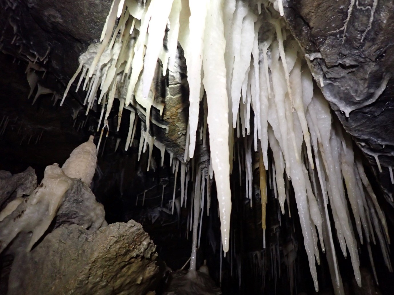
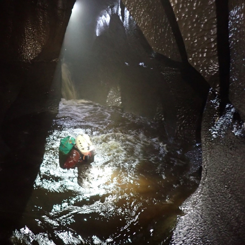
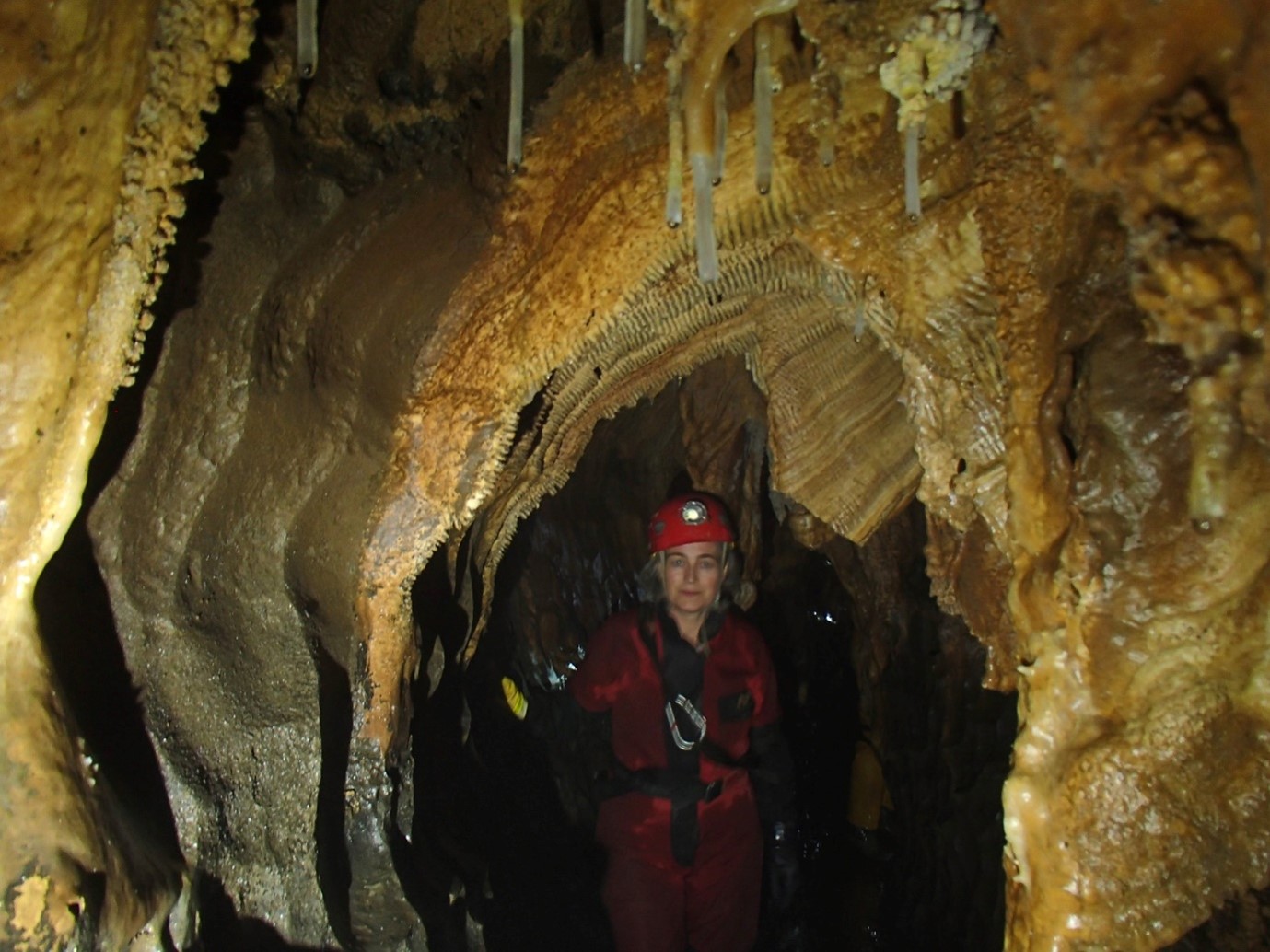
HELECTITES EVERYWHERE
Formations in the Grotte du Grand Roc. Photo by Linda Wilson.
There's no shortage of showcaves in
the Dordogne region of France and if you're trying to cram in as many
activities as possible, the Grotte du Grand Roc is worth bearing in
mind, as it's one of the few sites that remains open at lunchtime. Linda
Wilson first went there many years ago and till likes to go back with
visitors in tow.
The cave lies just outside the village of
Les Eyzies, with its famous Museum of Prehistory. Even in the height of
the August tourist season, it was possible for Jan Walker and I to turn
up and wait no more than ten minutes for a tour. Opening hours etc can be found on their website.
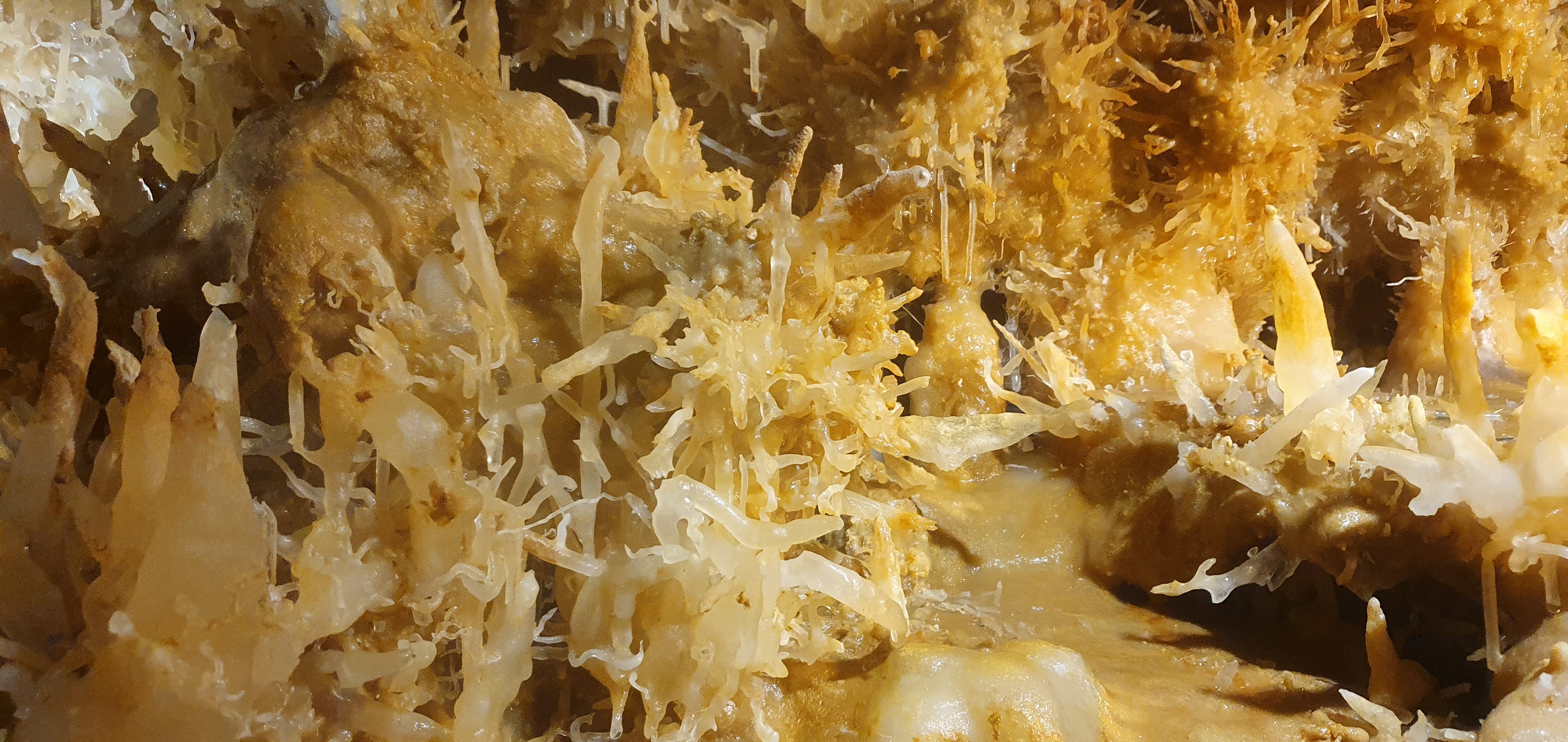
More helectites. Told you there was a lot of 'em! Photo by Linda Wilson.
The cave contains a forest of stalactites
and stalagmites, with helectites absolutely everywhere. A narrow path
winds sinuously between the formations, which are protected by thin wire
mesh. Photography is allowed and with the camera close to the mesh,
it's possible to get it to disappear from view.
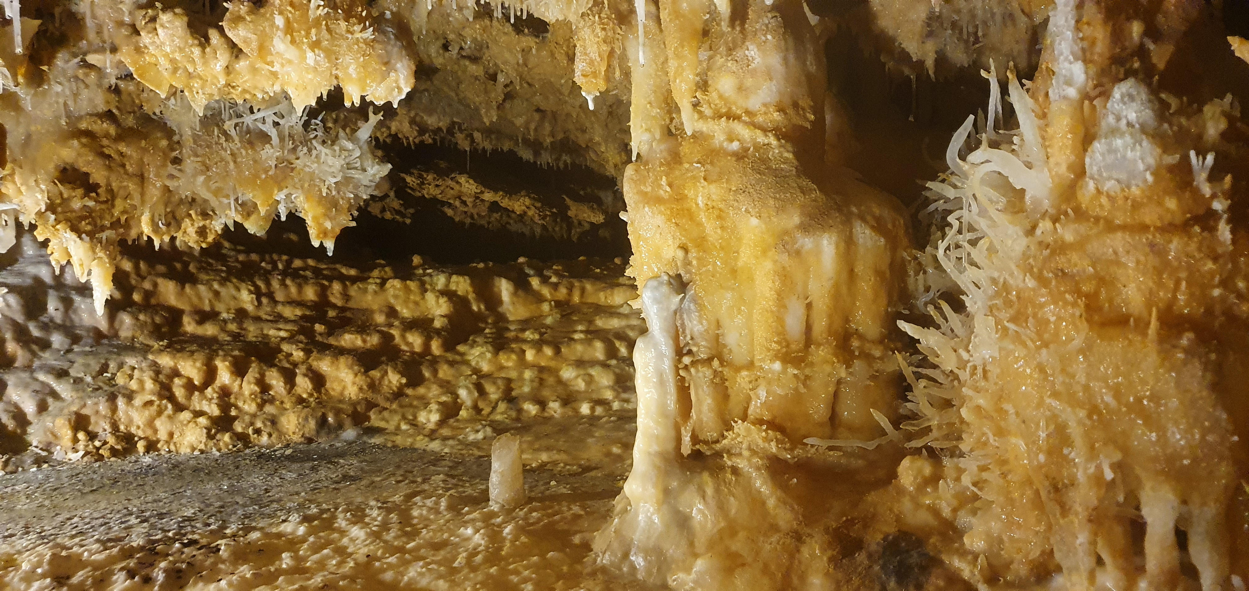
There's a few more here, too. Photo by Linda Wilson.
Despite being opened in the 1920s, the
damage is reasonably minimal, and there is very little evidence of the
algae growth that affects all too many showcaves.
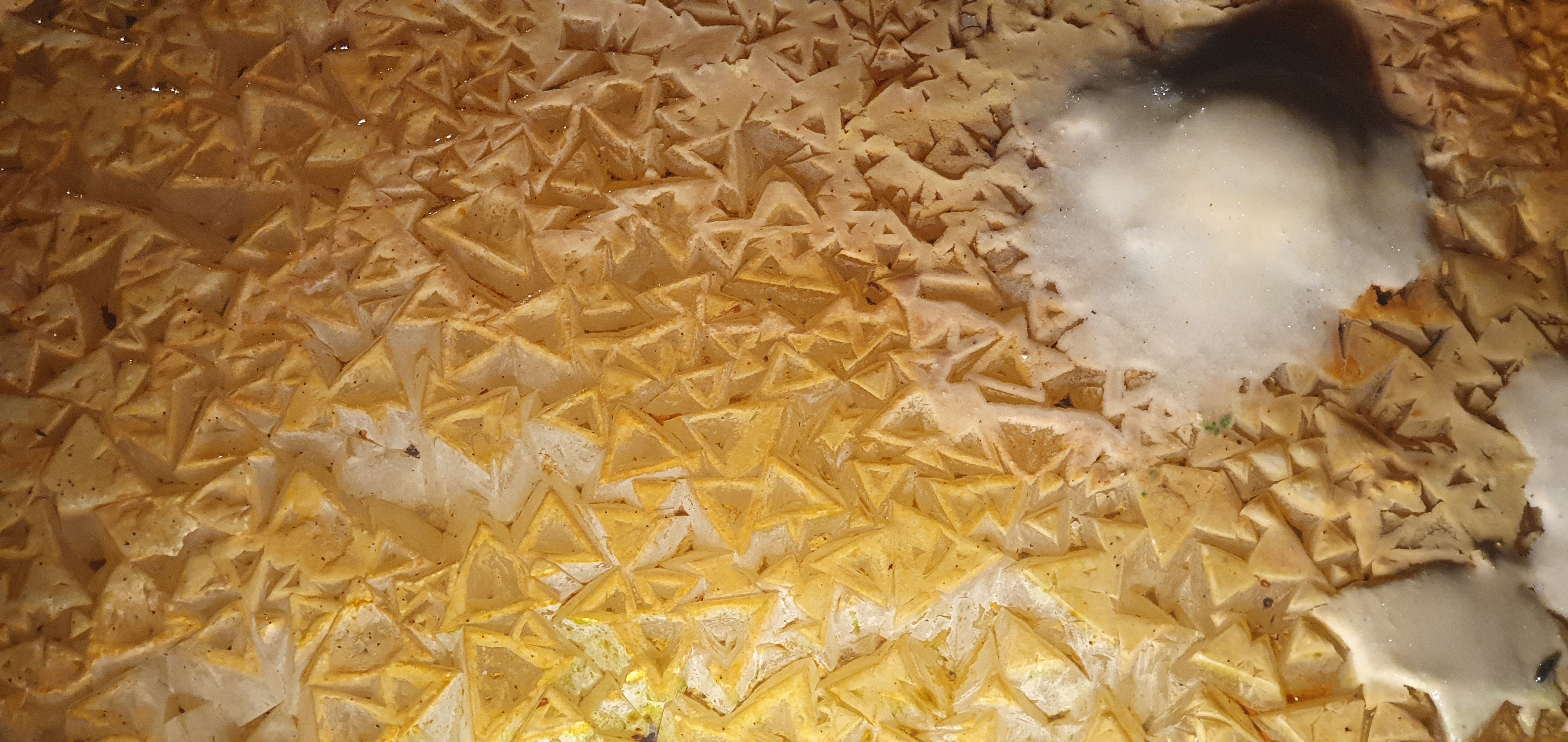
Weird little triangular thingies. Photo by Linda Wilson.
I've seen these weird triangular shapes in
stal on the floor in several showcaves in France and on most occasions
they claim to be the only ones in captivity. Explanations vary as to why
they form like this, so if any of our geologists would like to provide an explanation, I'd be most grateful.
This is a nice little cave that's well worth a visit.
Linda Wilson
|
|
CAPTION COMPETITION TIME!!
Rules: You can submit as many
entries as you like. They can be as long, or short as you like. They can
be clean or rude. The editorial team will grab a third person to help
with the judging. There will be A Prize!
Please send in your competition entries to Zac!
|
|
BETTER LATE THAN NEVER!
Pretties in Doolin Cave. Photo by Andy Morgan.
It's summer, and that means it's
time to head off to County Clare for some Irish caving! As this issue
goes to press, Ash Gregg will be cracking the whip again over yet more
surveyors down Coolagh, but on days off, there are plenty of other caves
to check out, as Paul Savage explains ...
The UBSS name is synonymous with caving in County Clare, and so of
course, as a member of UBSS, I had to see what all the fuss was about.
It only took me 20 years of caving, and joining UBSS again, to finally
get there.
The seed was planted when I discovered that one of our regular caving
cohort with the Grampian Speleological Group GSG, Jessie O’Shaughnessy,
grew up in Clare, and still had family there – with whom, she said, we
would be welcome to stay. Brilliant! A plan was hatched and, on the 12th
of May, a party of 5 cavers (Tamlin Barton, Andrew Morgan, Jessie
O’Shaughnessy, Julie Hesketh and myself) and a brand new copy of Caves
of Mid-West Ireland, boarded the Ryanair flight from Edinburgh to
Shannon.
After a comprehensive shop at the Shannon Lidl, we made our way to our
accommodation – Jessie’s dad’s farm, which was just east of Ennis (not
far from Spancilhill, if you’re a Christy Moore fan…) – a bit of a drive
to the Burren, but warm and comfortable. Jessie’s dad, John, was a
lovely host (a little bit bemused by our choice of hobby). I had, I
think, the best accommodation – in lieu of a spare bed in the farmhouse,
I slept all week in an old County Clare Minibus, with the seats removed
and a bed put in. Most peaceful! After settling in and cooking and
eating dinner, we sat down to make caving plans (and enjoy our duty free
Scotch…).
Day 1 – St Catherine’s 1 to Fisherstreet Pot
I awoke to a beautiful day – sunny and warm, and not a cloud in the sky.
I’ve been led to believe that Clare weather can be somewhat changeable –
but we were lucky it seems! The forecast for the next few days was set
fair, and the water levels were pretty low already – which meant that
none of our preferred caves were off the menu. Something that WAS off
the menu that morning was our friend Tamlin – he had enjoyed the duty
free booze a little too much the night before, and had decided to orally
redecorate the guest bedroom. Back to bed for Tam (after cleaning up).
The rest of us got ready and headed for our chosen cave of the day – the
classic Doolin Cave through-trip from St Catherine’s 1 to Fisherstreet
Pot. Arriving in Doolin, we decided to park opposite McGann’s Pub (for
easy access to stout après cave), and walk the 30 or so minutes up to
the St Catherine’s 1 entrance – not before locating Fisherstreet Pot (in
the middle of a field, surrounded by a small copse of trees and a fence
– just opposite an Irish Knitwear shop…) and rigging the ladder from
the tree above the entrance. We backed up to the fence posts surrounding
the pot – they seemed very new, and pretty solid.
Jessie about to rig the ladder pitch at the top of Fisherstreet Pot. Photo by Julie Hesketh.
Then – up the road to St Catherine’s 1 – past a number of stream sinks
on the right – and through some grand looking gates past a farmhouse.
The farmer saw us looking a bit lost, and immediately pointed us in the
right direction – along the farm track to an obvious cluster of trees in
a field by the side of the track – if you reach the house, you’ve gone
too far. And finally – 20 years after first joining UBSS – I got my
first taste of Clare caving.
If you want a relatively gentle and exceptionally fun introduction to
Clare caving (and the weather isn’t too wet), then the St Catherine’s 1
to Fisherstreet Pot trip is an excellent choice. After a short section
of crawling and through a slightly tighter bit (the guide describes this
as a squeeze, but I think that’s going a bit over the top), you arrive
at an abandoned bit of passage, with a number of routes – here we just
followed our nose – follow the polish, or go straight on (whichever
looks more likely). Even if it’s really dry, you should soon be able to
hear the water of the main St Catherine’s streamway. Once in the stream,
the going is easy, and (as I soon found out) this is very much Clare
Caving – a meandering streamway passage. If you don’t like meandering
streamway passages, then perhaps Clare isn’t for you. At one point the
stream leaves in a small side passage – and you are forced to climb up
into a higher-level passage – in the guidebook it says a climb to the
left – but I’m sure I got up with a narrow-ish scramble on the right of
the streamway. Anyway, the climb is easy and well-protected, and you
reach a very well decorated grotto – I think the Beautiful Grotto –
photo opportunities abound!
Paul Savage and Julie (peeking out) in the Beautiful Grotto, Doolin Cave. Photo by Andy Morgan.
It was in this area – according to the
guidebook – that there was a collapse in 2018, blocking the usual route
through. The new route at stream level is relatively easy to find (I
seem to remember some tat pointing the way) but it doesn’t look like a
place you’d want to be when it’s wet – bits of debris in the roof
suggest the through trip is definitely not possible in high water.
Anyway, this section is mercifully short, and soon you are through into
less oppressive passage. The streamway is followed for a short while,
after which a climb up into abandoned oxbow passages (again, easy-enough
route finding!) bypasses the Waddle (exactly how it sounds, even at low
water) and soon, you are stomping down the Great Canyon. This has got
to be one of the best canyon streamway passages around – broad, high,
with a solid or pebble floor, basically throughout. It isn’t often in
caves that you can stand two or three abreast, having a chat as if you
were walking down the high street. Great fun!
There were one or two side passages that we could have explored, but
time was ticking by, and that Guinness wasn’t going to drink itself. We
reached the end of the Canyon and found ourselves at the Second Bedding
Cave – not too bad at low water, but if you wanted to stay drier,
there’s a bypass – and reached the Aran View inlet. It’s here that we
began to notice a pretty nasty smell – having read other Doolin Cave
trip reports, it seems we aren’t the only ones to notice this, and so
this isn’t the place to stop for a refreshing drink. It’s also beyond
here that I saw fish and eels in the river and sediment – something I’ve
never seen before in a cave.
Continuing downstream, you know when you’re under Doolin village,
because there’s a number of inlets coming in from the ceiling that drain
from the Aille River that runs through Doolin; I guess there must be a
chert or shale band keeping the whole river from disappearing into the
hillside – but it’s an interesting feeling knowing there’s a whole
separate water course flowing above your heads. And then suddenly, the
mud in the floor starts to get thicker (and smellier), and the roof
starts to get lower, and then – daylight! And, thankfully, the bottom of
our ladder, at the base of Fisherstreet Pot. A quick ascent, and out
into a wonder sunny day. Be prepared for some odd stares are you appear,
muddy and wet, from the middle of a field in front of the knitwear shop
– not everyone is in Clare for caving.
Paul climbing out of Fisherstreet Pot, Doolin Cave. Photo by Andy Morgan.
Anyway, back out and changed – a good wash
of the face and hands – and a half-pint of some of the best Guinness
you’ll ever drink at McGanns. A brilliant introduction to Clare Caving!
Day 2 – Coolagh River Cave - Polldonough Main Entrance to North Exit
Another beautiful day in Clare, and so we decided instead of doing
Poulnagollum (our initial plan), we’d take our chance to get a trip in
the Coolagh River Cave because of how settled the weather was. The route
guide had severe warnings about flooding, and we probably wouldn’t have
a better opportunity to get through this highly recommended cave.
Certainly, the pictures in Selected Caves of the main passage looking
like an accident in a brewery (v foamy) gives the cave a bit of a
foreboding air, even if the weather was unseasonable warm and dry.
Looking at the survey, it appeared that a number of through trips were
possible, and we decided to try and find our way from the Main
Polldonough entrance to the North entrance. I was intrigued by the route
guide suggesting this passageway becomes “notable aquatic” towards the
North entrance; I can confirm that the route guide is entirely accurate;
this way also can be quite strenuous, especially for the bigger-boned
(i.e. me) – but we didn’t know this at the outset!
We parked in a layby just past the cross-roads to the west of the Main
Polldonough entrance – and also just south of the North entrance.
Beautiful weather to get changed in (definitely Grade 1) accompanied by
the sound of a barking dog…barking dogs are apparently a common thing
near cave entrances in Clare. Then to find the entrance – it looks easy
enough on the map, but Spring had sprung, and the vegetation was
luxuriant. We found it was easier to walk a bit further than you think
you need to, before heading down the south edge of the gully that leads
to the stream sink. In spring, this is a beautiful entrance – a wooded
glade, with a babbling river sinking under a natural limestone gate.
There is evidence of how seriously this cave floods even here, however,
with people-sized branches jammed four or five feet above the stream
sink in the wall of rock. Roof-level debris abounds through the entrance
series – a regular reminder that this is not a place to be in flood.
Inside the cave, the going is reasonably easy – but compared to Doolin
Cave, this is a much more sporting trip – the passageways are all
slightly snugger and the meanders slightly tighter than the previous day
– so you’ll get a good workout. Also, the trip is wet! Even in very low
water, you are soon on your hands and knees in the streamway – the
passage continues this way, changing from tall and narrow canyon to
lower bedding plane caves. I would also describe this part of the cave
as quite gloomy – this was probably not helped by the foam and jammed
branches that reach up right to the roof of the cave.
There are some parts of the cave where the streamway is impossible to
follow, and you need to get around in fossil passages (there’s an
interesting slot that exits at the top of a 2m pitch, which could be
tricky for short-limbed cavers) – but these are well polished, and don’t
stray from the streamway often. Once the roof really lowers and you
have to get properly wet (i.e. up to elbows in the water) you know you
are in the First Bedding Cave, and soon to drop into the main
Polldonough Drain – a magnificent bit of streamway passage!
The Polldonough Main Drain is high and the walls are beautifully
scalloped in places. The water flows fast, making the traversing of
flumes, chutes and pools a lot of fun, and something than might easily
end in a soaking! Even if you’ve somehow managed to stay completely dry
so far, you’ll get “refreshed” at Balcombe’s Pot, a fun 1.5m sluice
which ends in a 5m-deep pool – my recommendation is to stay to the right
of the passage, and push off from the base of the sluice to
“gracefully” skim across the water to the other side (see photo for
example).
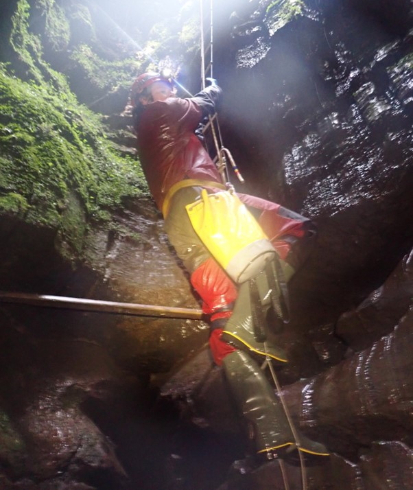
Tamlin tackling Balcombe's Pot. Photo by Andy Morgan.
Following Balcombe’s Pot, the main
streamway continues until it turns sharply left, with a broad, steep
muddy inlet entering on the right – this is the Cascade Branch, and the
way out through Polldonough North. We climbed the inlet and ducked under
the wall into the parallel passage to the left, which carries the
streamway, which we were to follow all the way out of the cave. The
first bit of this passage is generally easy going and climbs up a number
of pretty cascades in quite steeply inclined bedding, with a prominent
chert band. This, unfortunately, doesn’t last, and Polldonough North
soon closes down.
What follows is a series of relatively tight and low (compared to the
rest of the cave) meanders in the streamway – these can get quite wet
and grovelly – with some passages requiring excavation. There are also
some difficult passages to get around if you are tall and/or broad (this
is if you stubbornly follow the streamway, of course – and apparently
there are easier oxbow bypasses to a number of these grimmer bits…we
didn’t find any of them! Perhaps they’re easier to locate on the way
in…)
…anyway, soon enough we started to see daubs of reddish-brown mud on the
walls of the cave. We knew from the description that the entrance drove
through this mud, so we knew we were on the right track. Soon enough we
started the climb up the rift, out of the streamway and into the roof
passage – and out through the Polldonough North entrance. Here, the
route guide does a good job describing the colour of the mud, but is
perhaps a little coy on the amount and stickiness of said mud. It is
unavoidable that you will come out of this cave looking like you’ve
fallen in the long drop at the Burrington Hut! This entrance looks quite
loose and we thought it might have moved recently – so perhaps be
careful right at the top of the rift! Anyway, after exiting in beautiful
weather, we made our way back to the Polldonough stream sink to wash
some of the worst of the mud off. To cap off the day we made the most of
the beautiful weather to take a trip to the cliffs of the Burren Coast.
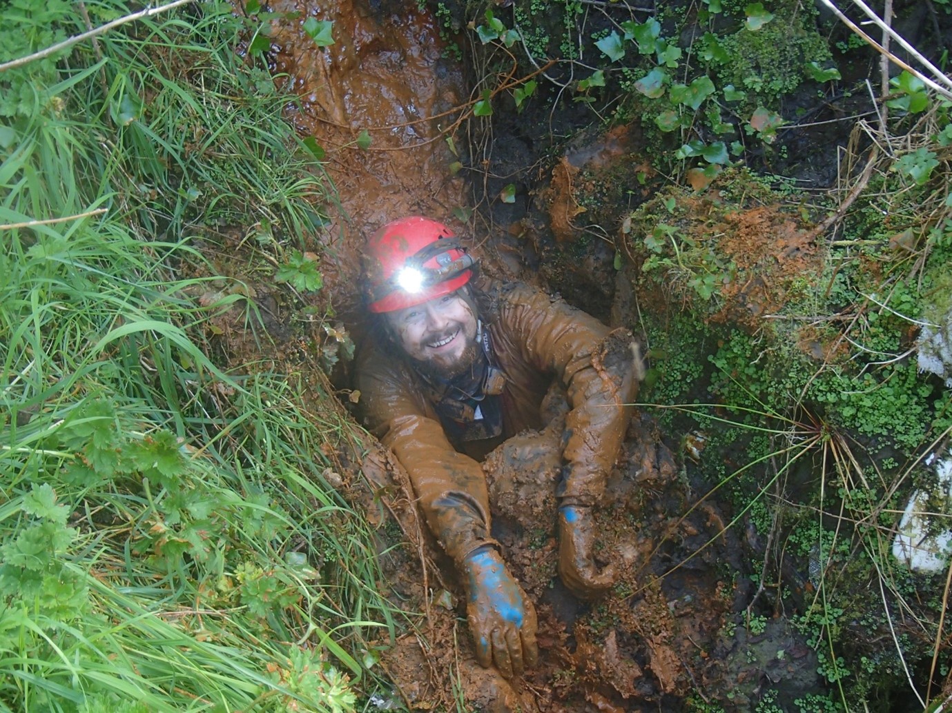
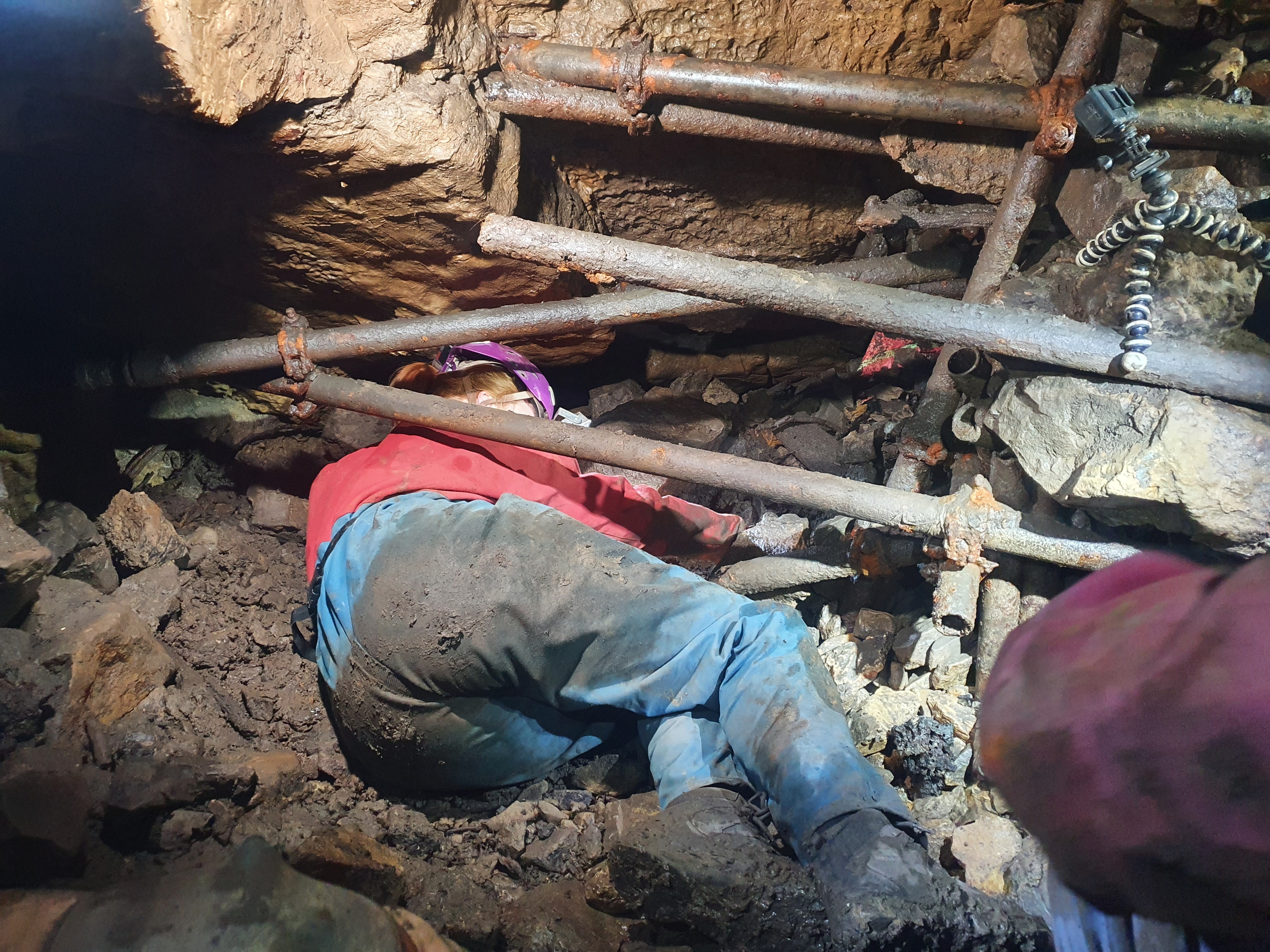
Paul exiting from Polldonough North - the mud is quite tricky to avoid. Photo by Tamlin Barton.
Day 3 – Cullaun Two
Again, we awoke to another lovely day.
Poulnagollum on the cards?…No! Everyone was feeling a bit knackered
after the Polldonagh North passageway and fancied a bit of an easy trip
and, given the nice weather, a bit of a sit out in the sun – it was a
Sunday after all! So, having consulted the guide, the Cullaun Caves were
chosen – first we’d look at Cullaun 2, then see what else we fancied.
We parked at a large lay-by around 100m south of the cave entrance – to
find a campervan (with UK plates) already parked up. A dog was tied up
outside – but no sign of people... As we got out to change, we all
noticed the twitching of curtains in the van – a bunch of semi-naked
pasty white cavers is probably not what these tourists expected to see
on a quiet Clare morning.
Finding the cave was very easy – Cullaun 2 must be a very popular trip –
as the entrance has a well-kept path from the main road. The entrance
is in a small wooded area, and the dry gully passage descends quickly to
join the main streamway – it’s this that you follow for the majority of
the cave for the easiest route to the final pitch. This is also where
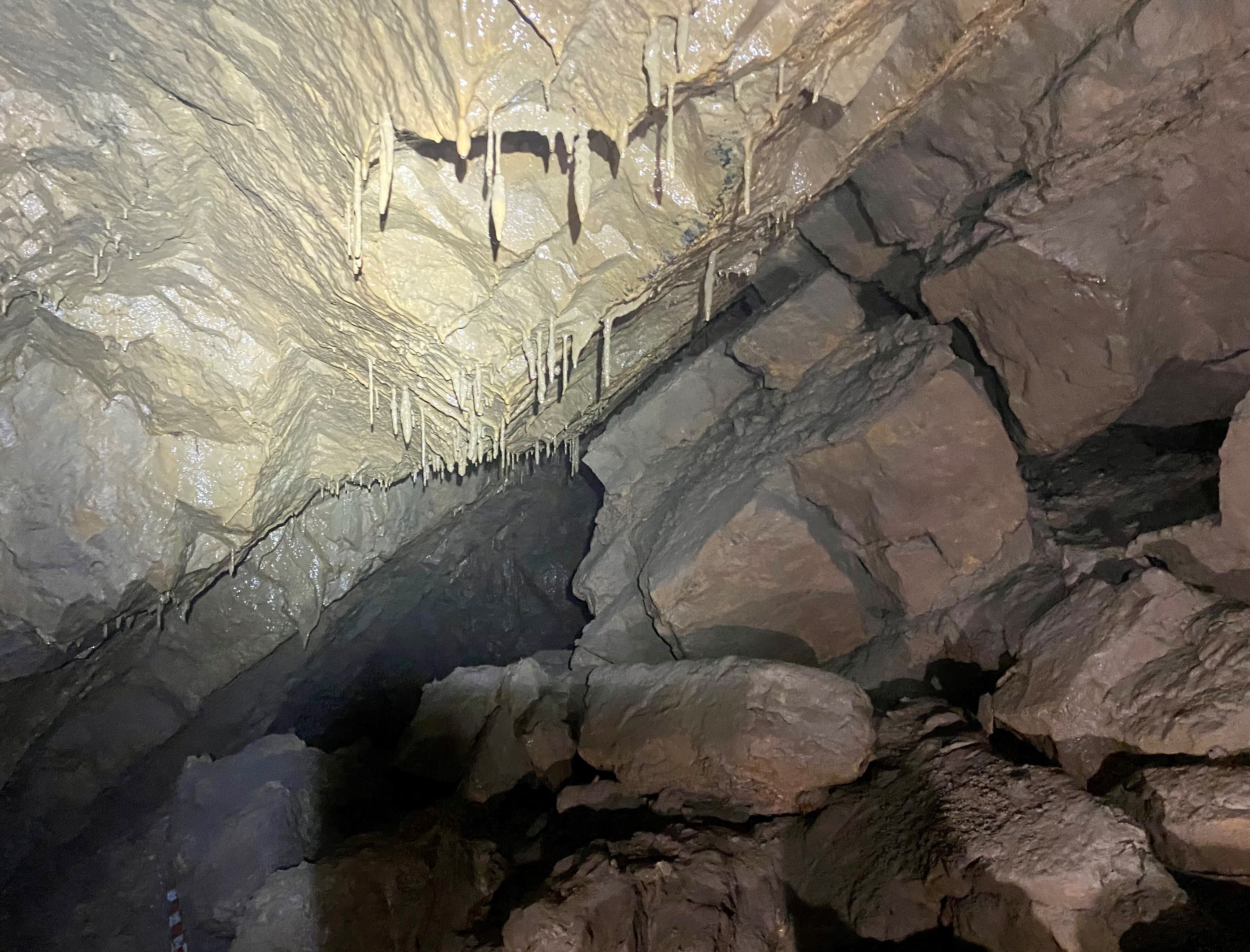
you come across some quite dramatic pretties – the Bloody Guts is the
most obvious – with white calcite mixed with red (I imagine iron-oxide?)
streaks. All the way to the final pitch, the going at stream level in
Cullaun 2 is very gentle – and it’s all quite pretty, for very little
effort.
'Bloody' pretties in Cullaun 2. Photo by Andy Morgan.
Soon we reached a widening of the
passageway, in a pool-floored chamber (called Pool Chamber, I think!) –
it’s here that the upper-level fossil passage can be accessed for a
different return route. The easiest way to get into this is to head
around to the right at the far end of the Pool Chamber, and climb up
again the right-hand wall, up an easy 2-3m climb to a high-level bedding
plane – which allows for an easy traverse over the main streamway
passage and into the abandoned stuff.
Paul staring in consternation at evidence
of hooligans, Cullaun 2. Photo by Andy Morgan. (If anyone would like to
own up, we promise not to name and shame - much, anyway!)
Before we headed back, however, we popped
the short distance down to the top of the final pitch. This is probably
free-climbable, especially in low water, but without a long-enough
handline we decided that discretion was the better part of valour, and
turned around at this point. I did notice some UBSS graffiti on the wall
above the final pitch…which miscreant is responsible for this?!
Graham?! LINDA!!!?!
[MOST CERTAINLY NOT! OUR HONOUR HAS BEEN IMPUGNED! WE DEMAND
SATISFACTION, SIRRAH! *Slaps hard with caving glove* A DUEL! - LJW/GJM]
After recording the evidence, we headed back up to Pool Chamber to take
the Old Streamway route (upper abandoned passage) back out. After
traversing above the stream, the roof level crawl soon opens up into a
stooping dry passage – the “awkward trench in the floor” as described in
the guidebook definitely lives up to its name. Climbing down from the
roof level at Dome Chamber, we were soon out into the glorious Irish
sunshine, and headed to Ennistymon for an ice-cream. Early back to base,
and another evening with good food and great company.
Day 4 – Faunarooska
Our final day’s caving in Clare and my lack of cave fitness was
definitely showing – I was pretty knackered and didn’t really have the
energy to tackle a long cave…this view seemed to be reflected be the
rest of the party, and we chose Faunarooska as a short bimble to cap off
our time in Ireland. In fact, it turned out to be one of the prettiest
caves we’d been in all trip – well worth the visit, especially if you’re
looking for a photography trip with very little effort.
Finding the cave was relatively easy – we parked just before the
junction with the farm track that leads NE up the hill. We thought might
be easiest to head directly east to the entrance of Pollballiny (as
this is easily located at the corner of a forest) but the vegetation and
bog is pretty deep here, and it’s much easier to continue further along
the farm track, then follow an old wall East directly to the entrance.
Faunarooska is another cheery stream canyon cave: good fun, lots of crab
walking and crawling, with some fun and easy climbs down cascades. The
best thing about the cave is, the further you head in, the prettier it
becomes, and eventually you have to be very careful not to touch
anything calcited – this place must have been absolutely stunning before
humans stained the calcite beige, but it’s still a really pretty cave
to explore.
Julie and some of the pretties in Faunarooksa Cave. Photo by Tamlin Barton.
There’s no route finding in the cave –
simply follow the water – and after a short while, the cave changes
character (as the guidebook says, it goes from vadose to phreatic). From
this point there’s a number of routes to explore – of these, my
favourite was an easy high level roof traverse, which ends in a
straw-filled grotto/aven. According to the guidebook, you can descend
the rift you’ve traversed above, but it soon ends in a muddy sump/choke,
so I don’t think I missed much!
After a number of photo stops, we were back out on the surface – and it
was still quite early. We thus decided that our caving trip had not
quite finished and decided to pay the entrance fee to see the giant
stalactite in Pol-an-Ionian (the “other” Doolin Cave).
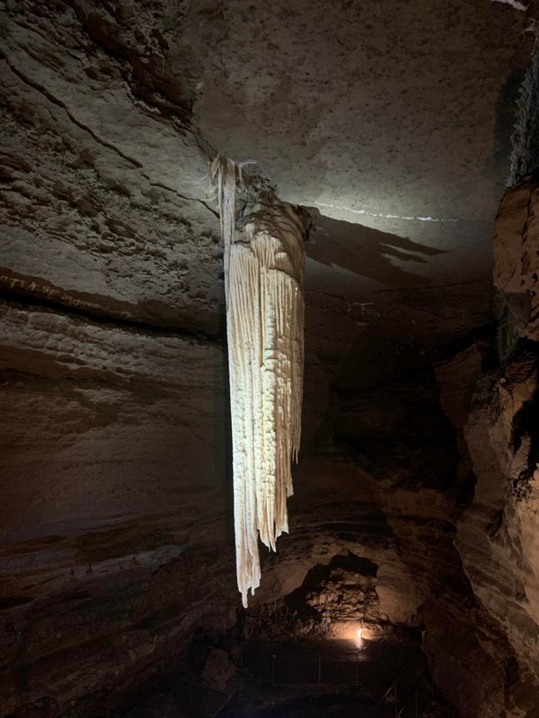
The whopper stalactite in Pol-an-Ionian,
known to past generations of UBSS cavers as the Soggy Dishcloth. Photo
by Julie Hesketh-Laird.
The formation itself is pretty amazing, so
big it’s actually difficult to grasp the scale of the thing – but the
cave is relatively brief and, if you’re short on money, I’m not sure
you’d be missing out on that much…I’m sure the original crawling passage
to get to the main chamber would have been much more rewarding than the
step-lined mineshaft that’s currently in place. Anyhow, the rest of the
party we were down with seemed completely amazed by the whole trip, so
perhaps I’m already a jaded old lag…
Day Five – Back to Reality
Sadly, all good things must end in another Ryanair flight, as the old
saying goes. I had a fantastic time in Clare – I’m so glad I finally
made the trip. We had amazing weather throughout, so we had our pick of
caves. We didn’t even get to do Poulnagollum, easily the biggest cave in
the area – which means I’ve definitely got to go back!
The trip itself was relatively cheap – the accommodation was free, and
Ryanair flights aren’t going to break the bank (at least, not in May
2022), so all we paid for was food, drink and petrol – which were on a
par with UK prices. What I really loved, as well as the caving, were the
people (who were ALL unreasonably friendly), and of course the scenery
of the Burren. A trip to Clare is HIGHLY RECOMMENDED.
Paul Savage
|
|
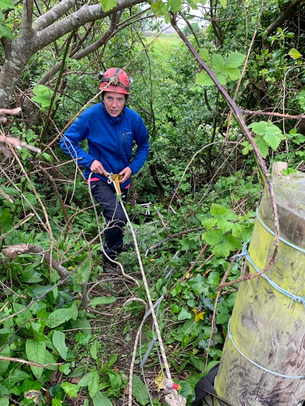
WHAT.WHICH.CAVE
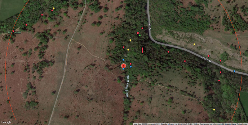
Caves in the West Twin Brook area,
Burrington Combe. Base image © Google and copyrights as given in image.
Cave locations by courtesy of the Mendip Cave Registry and Archive. The map is centred on West Twin Brook Adit. Image by Graham Mullan.
David Hardwick describes an
“interesting” evening trying to locate some seldom visited sites in
Burrington Combe, and quickly worked out why they aren’t on the Most
Visited List for the area. He also trialed a new method of locating cave
entrances …
Date: 22nd June
Party: David Hardwick, Breck Noel, Riley Noel, Amy Brander, Andy Beecher
I first met Breck and his brother-in-Law Mike, many years ago when, over
a beer in the Burrington Café (now sadly shut), they explained they had
bought some gear and a copy of Mendip Underground (probably from Bat
Products or Quipu for Leisure (both also sadly now gone) and intended to
do some caving. Dave Ebbs and I suggested they ought to join a club and
took them down Sidcot Swallet (sadly not shut!!) the following week and
they both became members and regular cavers in Hades CC.
Move forward probably a couple of decades and Breck’s teenage son Riley
is now keen to go caving. Following a trip with his dad a few weeks
earlier Riley had been scrambling around in the woods and had found a
cave entrance part way up one of the sides of the West Twin Brook Valley
(the one containing Sidcot Swallet and Goatchurch Cavern) which he
wanted to know more about and was dead keen to go and explore. With only
his dad’s secondhand description of where it was and what it looked
like, it wasn’t clear which of the various small cave features his son
had found but as it was June with long light evenings for searching, a
trip to “Riley’s cave” was planned.
Some internet work prior to the trip using the Mendip Cave Registry and Archive, Grid Ref Finder, and What3Words,
produced some suggested targets and some interesting anomalies, e.g. I
had always thought the large sink on the side of the path (the fenced
one) was Yew Tree Swallet, but it is actually Flange Swallet with the
Yew Tree one being some 7m higher up the slope – a possible target for
Riley’s cave entrance. Incidentally this also clarifies another anomaly.
It is often stated (including by a party member on this trip!) that the
water sinking at Flange is the stream seen in the lower parts of
Goatchurch whereas it is actually the Yew Tree Swallet stream that is
seen underground in that cave, which explains why there are times when
as you walk up the valley water can be seen trickling into Flange but
there is no stream in the Water Chamber.
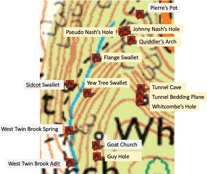
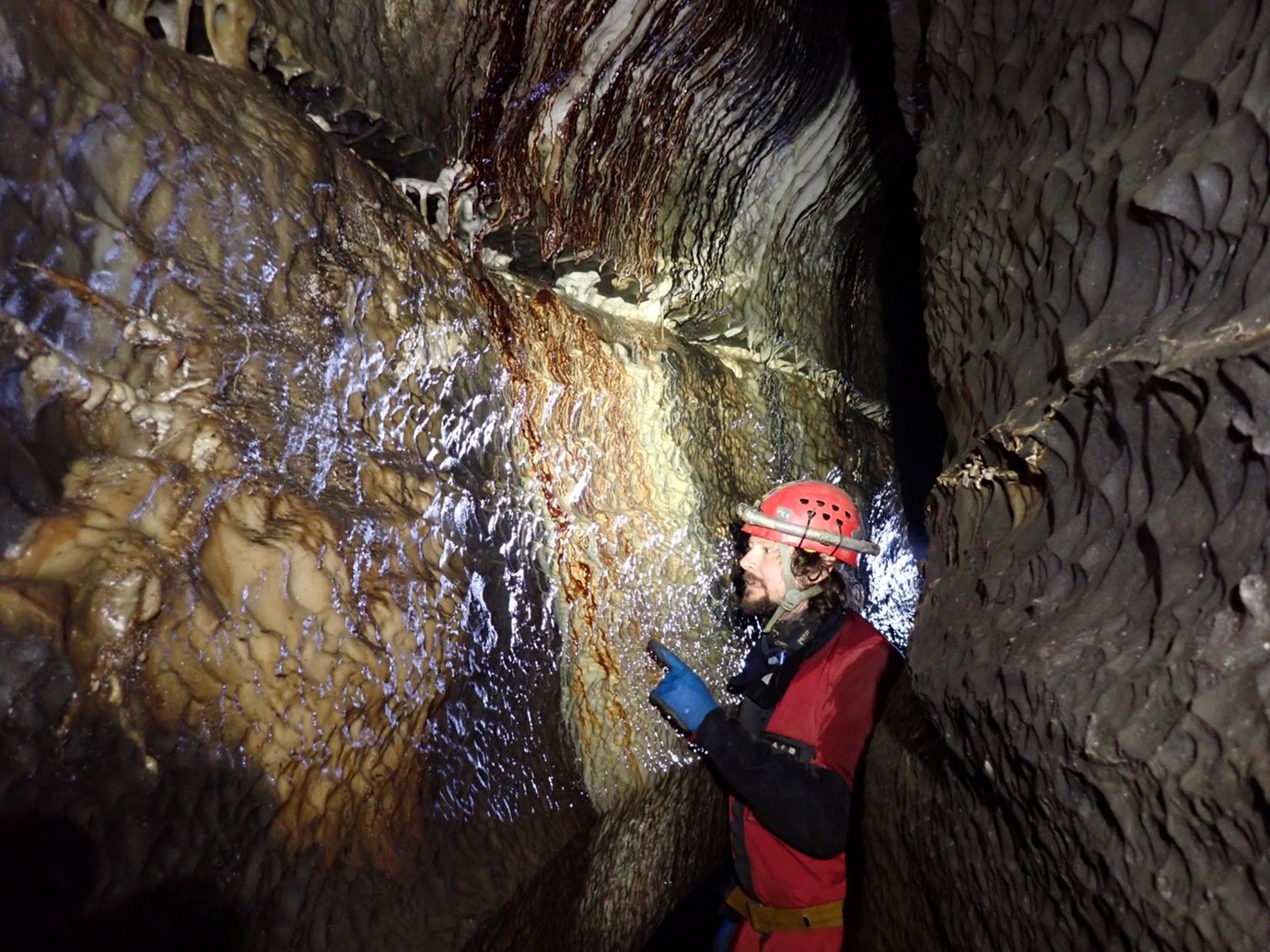
Image by David Hardwick.
A hybrid map using the above sources was
pulled together (see above) with sites I know well labelled in white and
those that I was less certain of shaded yellow. With hindsight It would
have been simpler to just photocopy the map for the West Twin Brook
Valley on page 190 of Somerset Underground Vol 2 but where is the fun in
that? The grid references given on the MCR were cut and pasted into
Grid Ref Finder which usefully gives a what3words reference for each
location and with that app on my phone we had our own GPS (Global
Positioning System), albeit with no altitude facility which would prove
to be important subsequently. I was keen to try to see how good
what3word was in finding an entrance and how accurate transferring grid
references into that format was. After the trip I also checked the grid
references on the MCA against those in Somerset Underground Vol 2 – see
tables in text below.
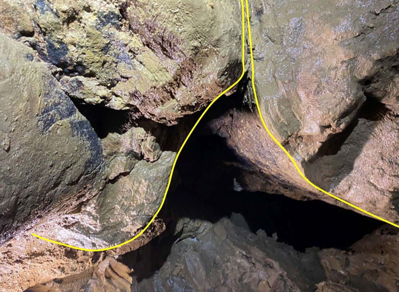
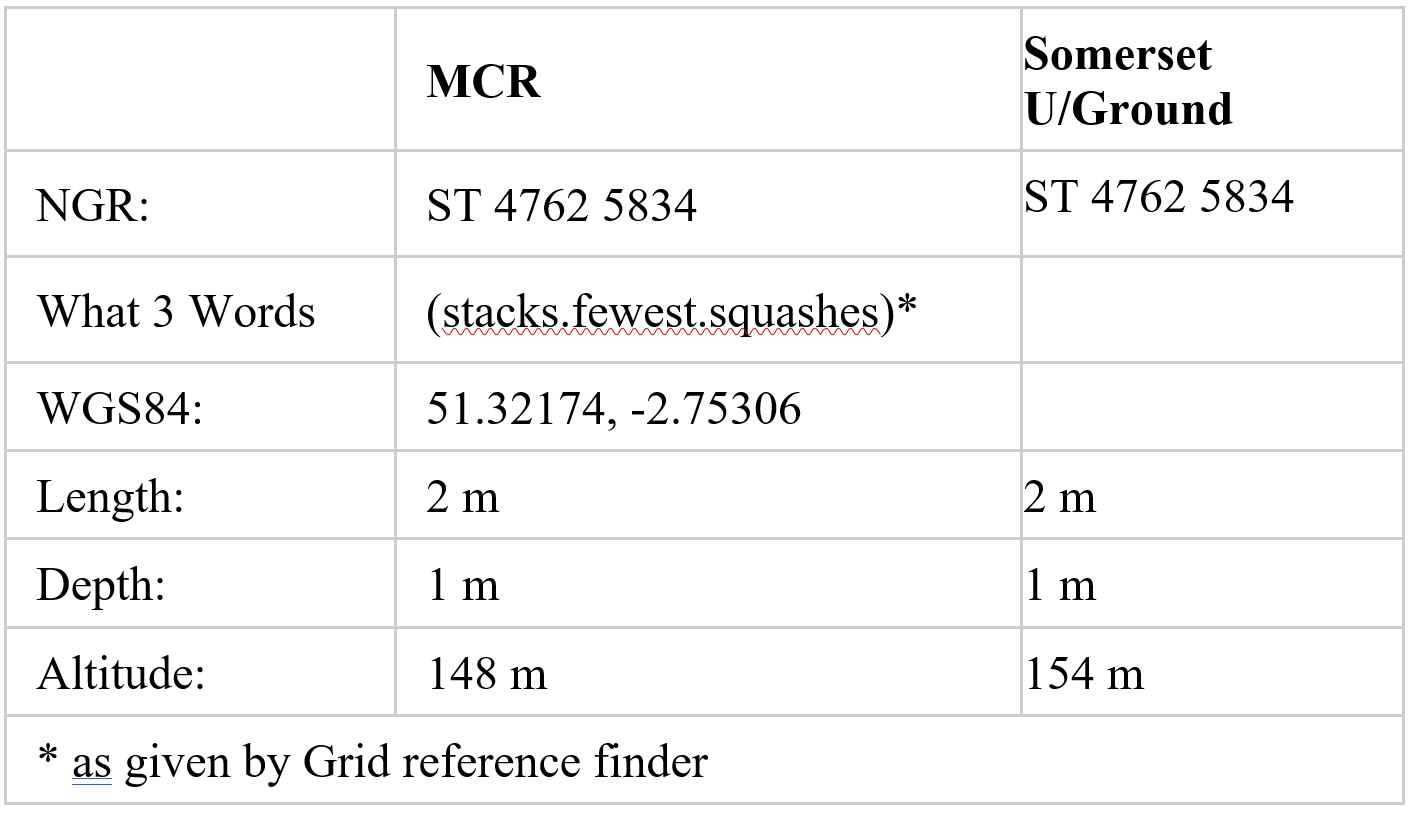
Pseudo Nash's Hole.
Our first stop was the small entrance on the side of the path (just past
Pierre’s Pot) which I had always thought was Johnny Nash’s Hole but is
in fact Pseudo Nash's Hole. This is described on the MCR as “Descending
tube leading to choke”.
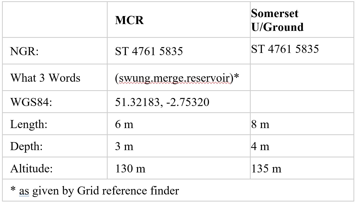
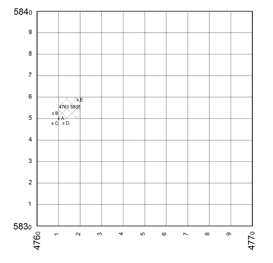
The length, depth and altitude in the MCR and Somerset Caves are all different but the grid reference is the same.
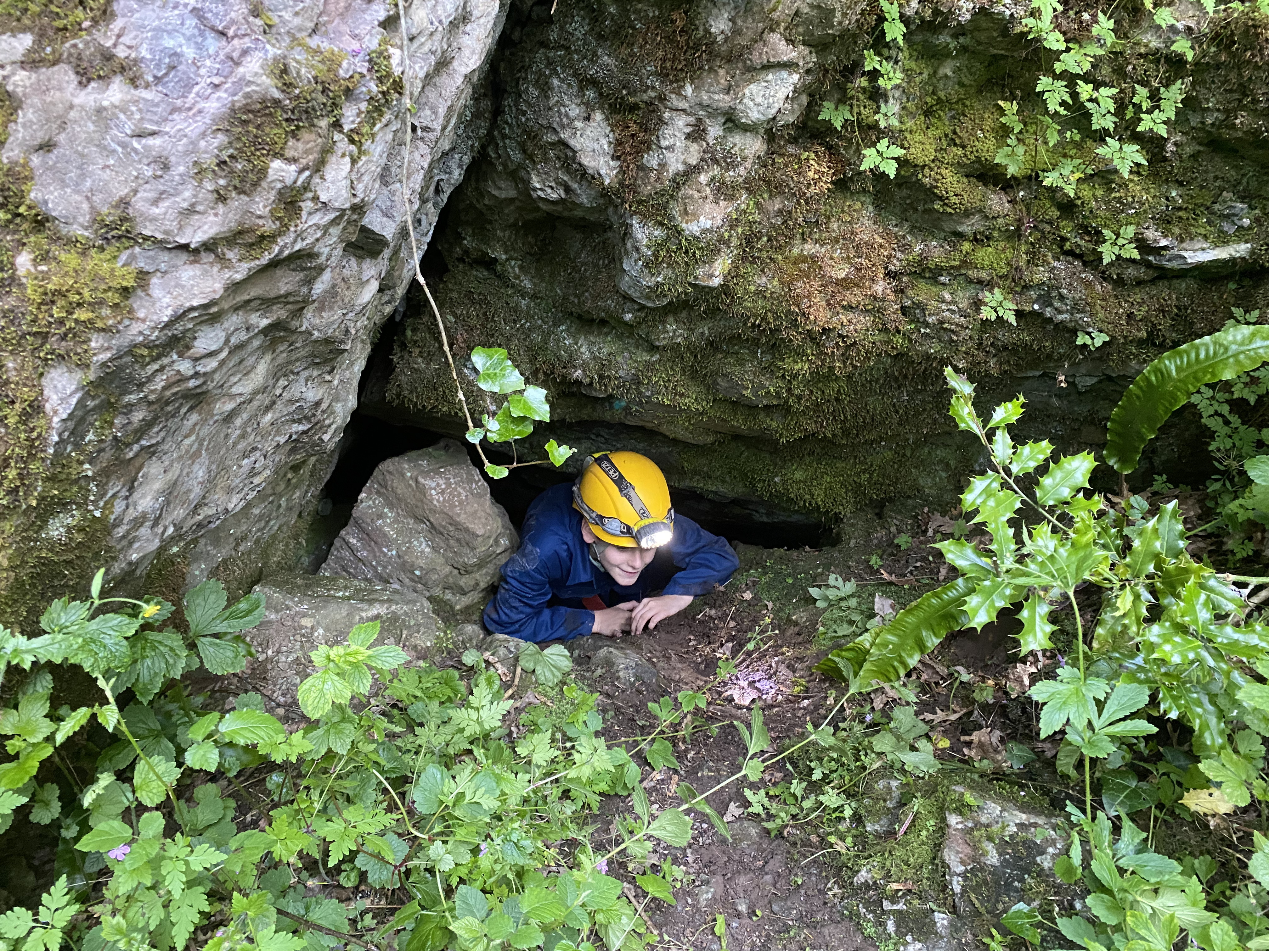
Riley in the entrance to Pseudo Nash's Hole. Photo by David Hardwick used with parental permission.
First a few words of explanation about grid references:
The what3words location used in this exercise was based on the MCRA
stated grid reference. An eight figure reference such as this actually
defines a specific 10m x 10m square within the 100km square defined by
the stated letters (in this case ST). In theory the site for which the
grid reference is given could be anywhere in that 100m2
square although most people use the grid to represent a fixed point at
the bottom left of the square, and choose the nearest one of these
intersections to identify the location.
For example, on the diagram below the large square represents a six
figure reference 476 583 (this is 100m x 100m) and the smaller hatched
square is the eight figure grid reference 4761 5835. Most people would
assume that the grid reference relates to the lower left corner (point
A). If you were trying to state the grid reference for a specific
feature at any of the points B, C or D, since point A is the closest
corner, it would be logical (and sensible) to use the stated eight
figure reference for it, although each is actually in a different square
altogether and should therefore have the respective grid reference for
that square. In contrast, Point E is actually in the same square as
point A despite potentially being some 14m away.
 What3words
works on a 3m x 3m grid so in theory should get you closer to the
actual site. This would be the case if the what3words was directly
worked out based on the actual site rather than converted from a grid
reference but since there are at least nine different what3word squares
in any eight figure reference square (actually more because there would
be up to 16 other what3word squares that would be partially in the Grid
Reference Square) transferring from a grid reference will only be
approximate. I am not sure the mechanism Grid Ref Finder uses for
selecting which what3word square it allocates for a given grid
reference. It would be logical to assume that it is the one nearest to
the centre of the square, but it would be better in terms of finding a
site if it is the one nearest to the bottom left corner. What3words
works on a 3m x 3m grid so in theory should get you closer to the
actual site. This would be the case if the what3words was directly
worked out based on the actual site rather than converted from a grid
reference but since there are at least nine different what3word squares
in any eight figure reference square (actually more because there would
be up to 16 other what3word squares that would be partially in the Grid
Reference Square) transferring from a grid reference will only be
approximate. I am not sure the mechanism Grid Ref Finder uses for
selecting which what3word square it allocates for a given grid
reference. It would be logical to assume that it is the one nearest to
the centre of the square, but it would be better in terms of finding a
site if it is the one nearest to the bottom left corner.
This was why I was keen to see how close to the cave/feature the
what3words reference would get us. With Pseudo Nash’s hole the cave
entrance was only one square off so certainly good enough for finding
it.
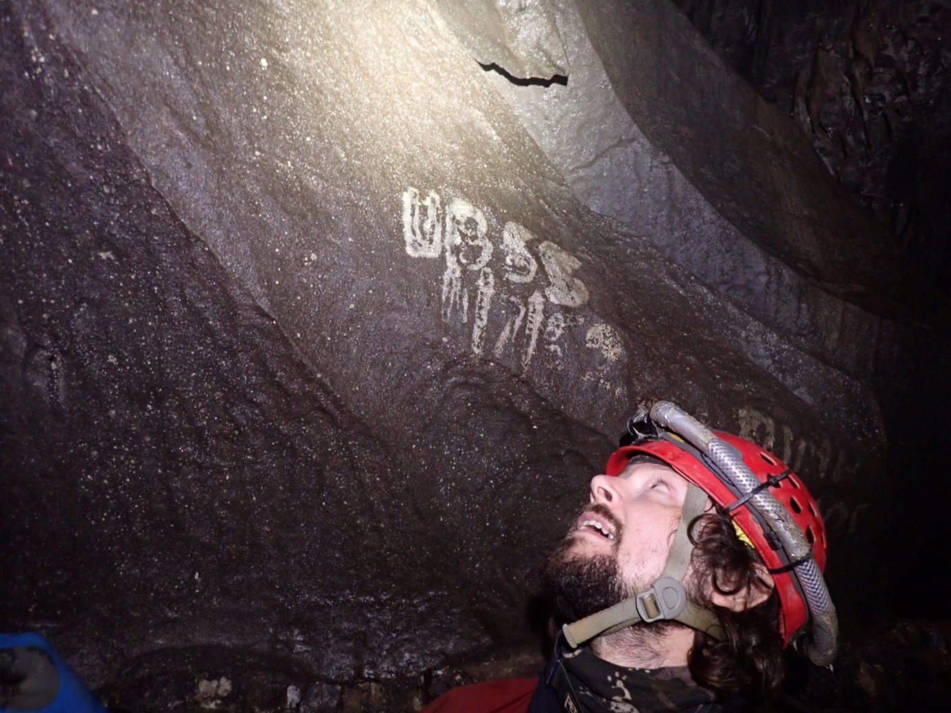
Our next target was Johnny Nash’s Hole (named after the UBSS member who
dug it in 1949) and what3words indicated this was further up the side of
the valley
Johnny Nash's Hole
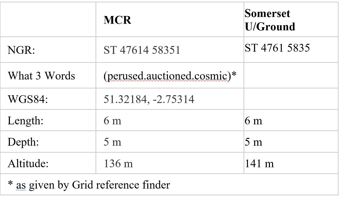
The MCRA entry for this one has a ten figure Grid Reference which should
take you to a 1m x 1m square. The Somerset Underground entry is only
eight figures (and that is the same as for Pseudo Nash’s Hole). The
altitude is again different, but both have it 6m higher then Pseudo
Nash’s Hole so the one further up the side of the valley was clearly
Johnny Nash’s Hole and I evidently had them the wrong way around. The
what3words one was again pretty much spot on at the entrance.
This cave turned out to be the one that Riley had found and clearly Mr
Nash was thinner than those on this trip with the exception to Riley who
managed to squeeze in. The MCRA description of “tight phreatic tube
[that] slopes down to tiny chamber]” is sufficiently close to that for
Pseudo Nash to justify why I had muddled them (at least that’s my
excuse). It does show signs of being solutional although certainly not
the circular tube the terminology suggests and even Riley didn’t get to
the end to confirm whether there was a chamber, as the Spiders were
bigger than he was!!
With our mission of finding, identifying and getting Riley into (albeit
briefly) “his” cave completed we could have just gone home but we
decided to make our way to Goatchurch Cavern for a quick trip but to go
via a group of three other sites on our list, Tunnel Cave, Tunnel
Bedding Plane, and Whitcombe’s Hole which conveniently meant also
passing Quiddlers Arch. The altitude details from the MCRA
indicated the arch was 12m higher up the side of the slope and so on up
we went.
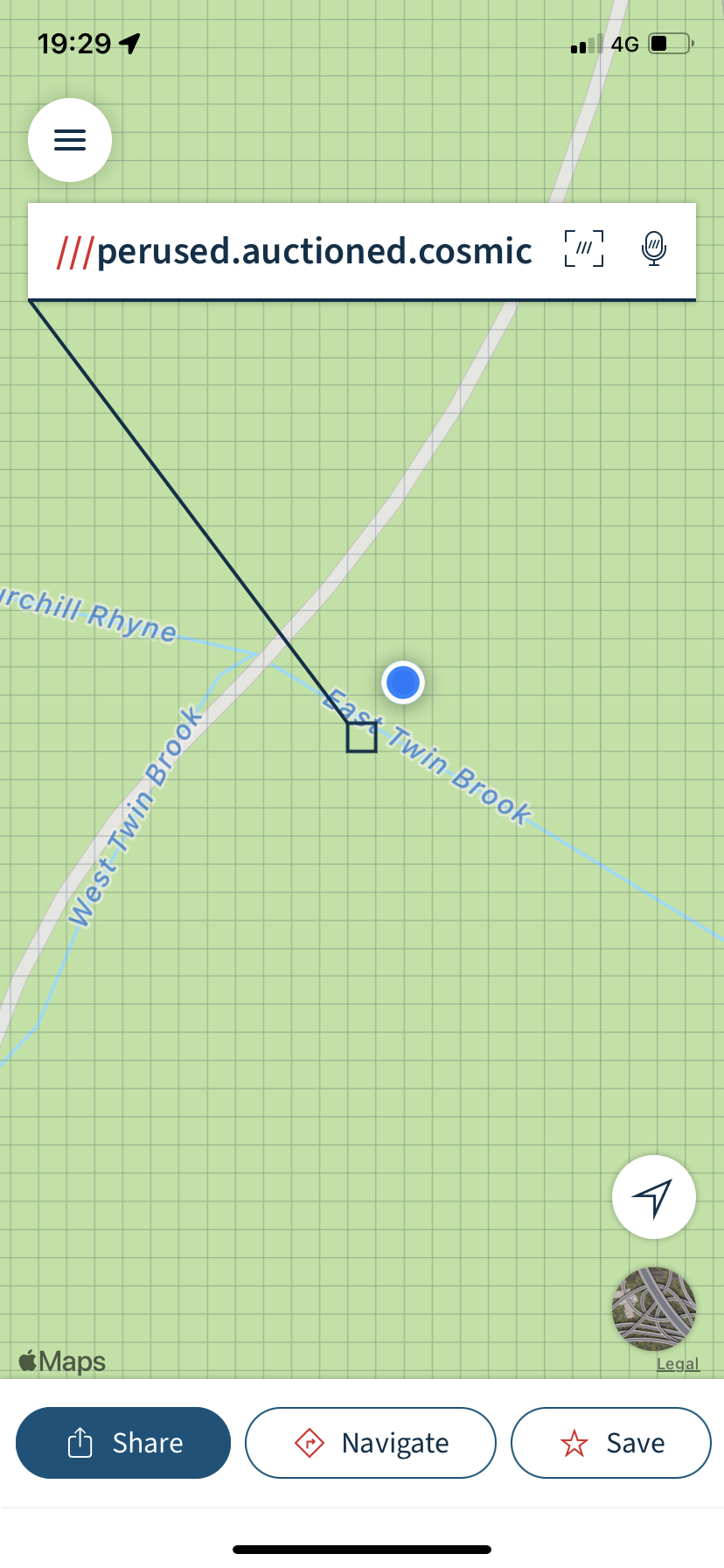
Quiddlers Arch
What3words was useful as once again we were within a metre or so when
the blue dot on the app (showing where we were) was inside the square
allocated the specific three words. An alternative three words
could well have been those in the MCRA description of “insignificant
phreatic arch” as it was only because the app said we were close that
made us take a second look at what appeared to be just a small recess in
the rock. Andy Brander went to the other side and it was possible to
shake hands through the arch which is just about 2m total although where
the depth of 1m comes from I have no idea.
Tunnel Cave, Tunnel Bedding Plane
The altitudes for our next three targets were again higher up so we
continued scrambling up the rock face. The map shows these are all close
together on the opposite side of the ridge we had been scrambling up
and facing into Burrington Coombe rather than the West Twin Brook
Valley. It was however easier to work our way up the slightly less
overgrown valley side until the pitch began to shallow out. The App
indicated we were getting close so a quick drop down onto a ledge on the
far side brought us to our reference for Tunnel Cave, described in the
MCRA as “Two entrances lead to short section of phreatic passage.” At
this point we could see was a low slot no more than 6” high into what
could be argued to be a bedding plane (Tunnel Bedding Plane perhaps?) or
was this just one of the entrances to Tunnel which was now blocked? A
few metres further on, just around a rocky corner was an obvious tunnel
like entrance. Fully expecting this to go to a connection with what we
believed to be the second, now filled, entrance we went in only to find
it a dead end. A nice little cave, clearly phreatic with some flowstone
and about the right length to be Tunnel Cave it fitted the description
except for the lack of a second entrance. It is almost horizontal but
slopes up slightly at the end but it is difficult to justify the stated
4m depth range for Tunnel Cave. The MCRA description for Whitcombe’s
Hole however is a “Small choked phreatic passage” and its comparable
length and depth range of just 2m meant it could well be that one which
we were in. This could mean that the low small slot was Tunnel Bedding
Plane and we had missed Tunnel Cave by coming over from the other side. A
quick check did not however reveal any sign of Tunnel Cave at the
height we were at. To clarify we set off to see where our what3words
reference for Whitcombe's would take us.
Whitcombe's Hole
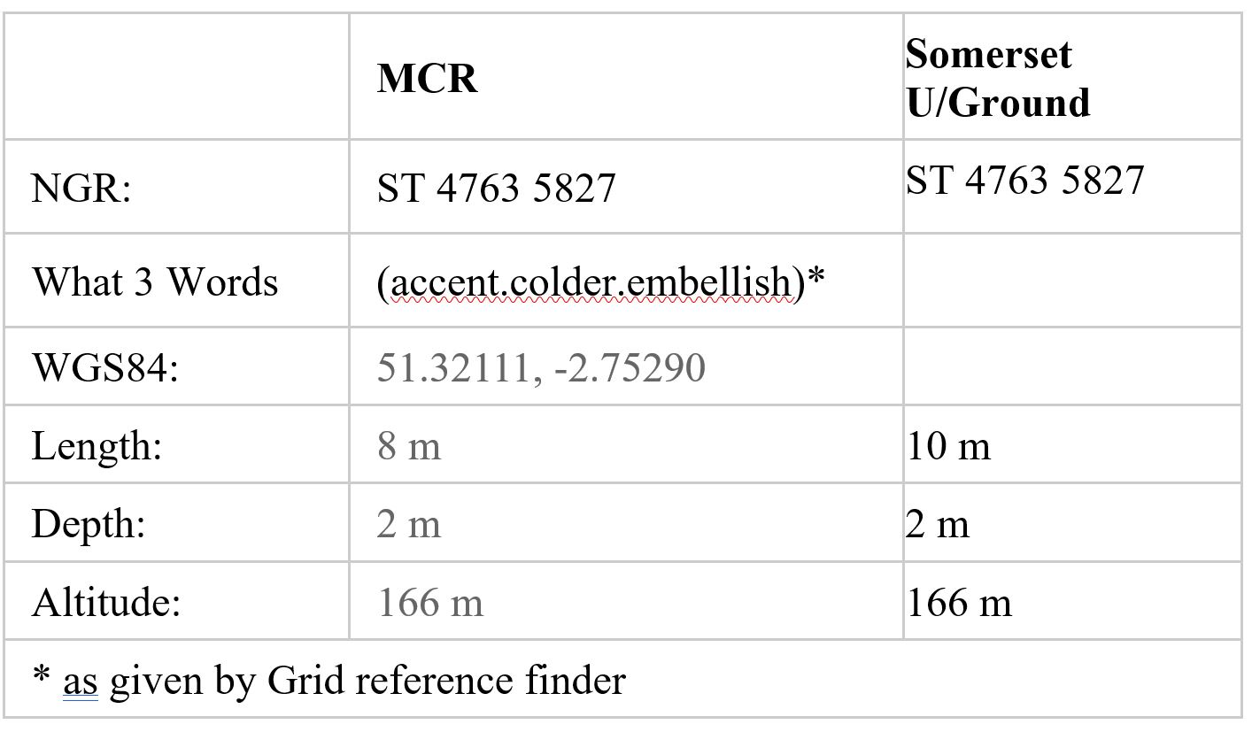
After fighting our way through dense vegetation, with the app struggling
at times to relocate itself (due presumably to tree cover), as well as
me pressing wrong buttons !! It eventually lead to a location at the top
of the cliff almost directly above the entrance to the cave we had
previously found, confirming we had actually found Whitcombe. On a steep
slope such as this even a distance of 3m away horizontally could put
you quite a long way above the cave entrance you are looking for. At
this point we checked the altitudes, which we probably should have done
earlier and realised with Tunnel was 8m lower down the slope. The small
hole we found at the what3words location we had for Tunnel Cave is
unlikely to be Tunnel Bedding Plane as according to MCR that should a
further 2m lower than Tunnel Cave and not at about the same height a
Whitcombe. The Somerset Underground altitude for the bedding plane is
however 6m higher than its reference for Tunnel Cave but that still
makes it 3m lower than its reference for Whitcombe. The Somerset
Underground grid references are again only eight figure so as a result
they are the same for both the “Tunnel” features with Whitcombe being in
the 10mx10m square immediately south of that. Despite these sites being
so close together the approach of using what3words had not enabled us
to find them possibly because of the lack of clarity regarding the
altitude.
With enthusiasm for fighting through the brambles fading, suffering
numerous cuts from brambles and bracken and being eaten alive by flies
we decided to take in the late evening sun and splendid view down the
gorge and then make our way over to Goatchurch Cavern for a quick trip.
Riley, despite having been in Goatchurch several times, had never been
through the Drainpipe so a yomp through that was in order. A slip and a
fall on the way out for Andy Beecher finished off the evening with a
painful self-rescue with assisted handline out the Tradesman’s
Entrance to round off a long evening which despite it being the
day after the summer solstice still meant coming out in darkness and
missing the pub.
Conclusions
Riley in 'his' cave. Johnny Nash's Hole. Photo by David Hardwick used with parental permission.
On this occasion we managed to identify the
cave that Riley had found, but finding obscure cave sites and
identifying which one you are actually at, is often difficult as proved
(once again!) by the limited success of the second part of this
trip. In dense foliage/brambles etc you could be within a few
metres of the destination and miss it entirely. Using grid references to
identify cave locations has long been the way they are identified but
how accurate and how precise they are differs. The skill and approach
taken by the first person recording the entrance location may vary and
it is likely that any error will be passed on and repeated in subsequent
publications. Eight figure references usually only take you to within a
few metres of the site. This is (usually) accurate enough to get you to
within sight of the feature but at times there may be more than one
site with the same reference leading to confusion. Using ten figure
references in theory gets you to within 1m of the chosen point although
this depends entirely on how accurate the person identifying the site
is e.g. if based on a feature shown on the map how accurate is the
map? The ordnance survey only guarantee accuracy to within a few
metres. Identifying the actual site location using a GPS should provide a
more accurate location than trying to manually add it to a map but
again the accuracy of the GPS device being used (usually depending on
cost) is again often only accurate to within a few metres.
The what3words references we were using were generally OK for finding
the cave by getting us to roughly the correct location even when only
based on grid reference that were only eight figure. The difficulty in
finding the later caves may have been partly due to the inaccuracy of
the original grid reference (which given the terrain would not be
surprising) and the difference in altitude in the two sources for the
Tunnel Bedding Plane does suggest this may be the case. It is of course
also possible that there has been confusion of which site is which in
the past with people thinking a site is one thing when actually it is
another (as with my mistake regarding the two “Nash” sites and the
common one regarding the two swallets). Obviously, no matter how
accurate a reference is to a particular location if it is not the site
you think it is anybody directed to it later will also go to the wrong
place.
Had we had a pen with us we could have made a note of what the
what3words app was giving for the actual entrance location for each
site. That would have given a more accurate identification for the site
than my method of transferring it from a grid reference. A what3word
location taken actually at the entrance could be used to direct a future
person to the same spot using the what3word app although again, if the
named site is not the correct one, the person following it will not go
to the correct place. Had I thought about it I could have noted down the
details on the phone or even used the save facility in the app
(although doing that when not entirely sure of where we were could have
resulted in uploading incorrect information).
Using what3words to find cave entrances has potential but only if the
reference is correctly located (by taking it at the site) and it is for
the actual feature you are trying to find.
David Hardwick
|
|
HISTORICAL NOTES ON AN “INTERESTING EVENING”
Our very own history nerd, Graham
Mullan, has provided some more information on a few of the sites visited
by David on his Burrington jaunt.
Flange Swallet (AKA Peter Bird’s Dig) is indeed the one with the fence
around it, placed when it was re-excavated with a JCB to prevent the
stream running down the road & ripping up the surface (No, Linda you
cannot take a JCB to Longwood Top Sink next summer!) [Aw, SPOILSPORT!
LJW].
The site of Yew Tree Swallet can be identified from the prominent yew
tree (doh!) [This is the only yew tree Graham can identify - LJW] but
the sink itself was completely covered by spoil when Bristol Water
excavated West Twin Brook Adit. There is a photo of it in ‘The Complete
Caves and a view of the hills’, cited by David. For the best account of
the hydrology see our article in Proceedings from 2009.
David is not the first person to have the problem of identifying the
cave you’ve actually found. Modern surveys and decent GPS require better
from us. When the sites around Whitebeam Slitter Cave in Cheddar Gorge
were being surveyed, for example, (see this survey on our website)
there was ‘great discussion’ over the site named Snablet’s Dig. The
problem was that nobody had ever been near the area with GPS before and
Snablet had only guesstimated the position of the hole he’d found long
before. Similarly, Pseudo Nash’s Hole has that name because ‘everybody
assumed’ they’d found Johnny Nash’s when in fact it was higher up the
slope so they hadn’t. Why Mr Nash named one but not the other is lost in
the midst of time and probably old UBSS Hut Logbooks.
According to Rob Taviner, who visited them when writing Somerset
Underground Vol 2, “There are three caves visible in the cliff which
slopes down at 30 degrees or so. Whitcombe's is the best and lies at the
higher end of the cliff. Tunnel Cave lies on a ledge near the lowest
point and has two entrances. Tunnel Bedding Cave lies at the foot of the
cliff in between and is basically a choked arch with only one entrance.
Both Tunnel and Tunnel Bedding Cave were mired in brambles when I
visited in April 2015. I suspect they still are. Just to confuse
things further Tunnel Bedding Cave has also been recorded as Whitcombe's
Hole 2. Nobody seems to know who Whitcombe was.”
Graham Mullan
|
|
PLEASE TELL CAVING RACCOON YOU READ TO THE END!
 Steampunk
Caving Raccoon image made by Linda Wilson using the Midjourney
Artificial Intelligence art generator. Yes, darlings, I have discovered a
new and fascinating way of procrastinating! Steampunk
Caving Raccoon image made by Linda Wilson using the Midjourney
Artificial Intelligence art generator. Yes, darlings, I have discovered a
new and fascinating way of procrastinating!
We're
pleased to announce a new winner this week, with David Hardwick jumping
into the lead, to make up for his previous poor performance of reading
at least a year in arrears! So congratulations, Mr Hardwick, I'll buy
you a beer next time I see you, providing I remember to bring some dosh!
(LInda).
-
Hey …. Who’s trying to steel my look? Colin (The Cool Camel) [David
Hardwick] [Subject to successful negotiations with his agent, Colin the
Camel might well appear in the next issue.]
- Oops, my browser cut off the end message! [Megan Malpas]
- Spiffing work, everyone! Excellent photos as always. And very
taken with Chris H's poem. He's a poet and he doesn't know it!
[Sharon and the esteemed FT Bear]
- Le chameau et moi ont lu jusqu'à la fin. Got a bounce back from
last email but Team France have read to the end! Lots of love from Real
Elaine, Zac "just a little crash" Woodford and Elliott Wasp McCall!.
[The French Connection]
- Excellent newsletter and some cracking caving done this month! [Jan Walker]
- Ok so I am a few days later than usual but in my defence we’re
trekking in Georgia. After 6 days in the middle of nowhere we got WiFi
today and this is the first thing I did, so maybe a half pint for
me? Great newsletter as always, very excited by the Scottish mentions!
[Kat Osei-Mensah]
- Nowhere near first but at least I submitted after release this time! [Zac Woodford]
- A belated confirmation of completion due to absence on a
long-postponed motorcycle tour up to Scotland. (Actually, not on a
motorcycle as my ageing hips won’t let me ride my BMW for more than an
hour. It was on a 400cc mega-scooter. A scooter… how the mighty are
fallen). Anyway, I’m grateful to Henry for introducing a very welcome
note of reality into descriptions of Mendip caves which in my experience
have often been written by Hobbit contortionists; I’m greatly relieved
that I never bothered with Wigmore. Anyone interested in a mint
condition 1988 BMW75S? [Dick Willis]
- Dear friend, I am stranded in Lyon with no money as it has all
been stolen. Please send a transfer to my account. I will pay you back.
[Fake Elaine] [No, piss off. We told you before, you still owe us for
the Amazon and iTunes vouchers we sent. We're starting to think you are
not really our esteemed Hon Prezz]
- She's not your best friend, I am! I have $5,000,000 to deposit
in your bank account immediately. Please send bank details by return. [A
Friend] [Hmm, sounds more promising, with that much, Henry could buy
Wigmore and fill it in.]
I did it, Caving Raccoon, I finally reached the end and it was brilliant!
THE END
|
|
|
|
